| Kupa / Kolpa | |
|---|---|
 River valley from Kozice | |
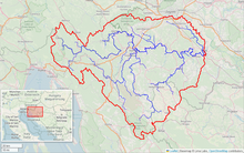
 Kupa River watershed (interactive map) | |
| Location | |
| Countries | |
| Physical characteristics | |
| Source | |
| • location | Razloge, Gorski kotar, Croatia |
| • coordinates | 45°29′28″N 14°41′20″E / 45.491°N 14.689°E |
| • elevation | 313 metres (1,027 ft) [1] |
| Mouth | |
• location | Sava, Sisak, Croatia |
• coordinates | 45°27′36″N 16°24′08″E / 45.46000°N 16.40222°E |
| Length | 297.4 km (185 mi) [2][3] |
| Basin size | 10,226 km2 (3,948 sq mi) [2] |
| Discharge | |
| • average | 283 m3/s (10,000 cu ft/s) |
| Basin features | |
| Progression | Sava→ Danube→ Black Sea |
 | |
The Kupa (Croatian pronunciation: [kûpa]) or Kolpa (Slovene pronunciation: [ˈkóːlpa] or [ˈkóːwpa]; from Latin: Colapis in Roman times; Hungarian: Kulpa) river, a right tributary of the Sava, forms a natural border between north-west Croatia and southeast Slovenia. It is 297 kilometres (185 miles) long,[2] with a length of 118 km (73 mi) serving as the border between Croatia and Slovenia[1] and the rest located in Croatia.[4]
- ^ a b Rivers, longer than 25 km, and their catchment areas, Statistical Office of the Republic of Slovenia
- ^ a b c "Sava River Basin Analysis Report" (PDF). International Sava River Basin Commission. September 2009. p. 13. Archived from the original (PDF, 9.98 MB) on 2010-07-17.
- ^ Ostroški, Ljiljana, ed. (December 2015). Statistički ljetopis Republike Hrvatske 2015 [Statistical Yearbook of the Republic of Croatia 2015] (PDF). Statistical Yearbook of the Republic of Croatia (in Croatian and English). Vol. 47. Zagreb: Croatian Bureau of Statistics. p. 49. ISSN 1333-3305. Retrieved 27 December 2015.
- ^ Surface streams and water balance of Slovenia, Ministry of the Environment and Spatial Planning