Kurnool district | |
|---|---|
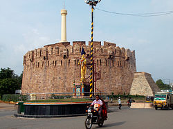
 Konda Reddy Burju | |
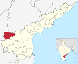
 Location of Kurnool district in Andhra Pradesh | |
 | |
| Coordinates: 15°50′N 78°02′E / 15.83°N 78.04°E | |
| Country | |
| State | |
| Region | Rayalaseema |
| Established | 1808 |
| 1st Reorganized | 1970 |
| 2nd Reorganized | 4th April 2022 |
| Headquarters | Kurnool |
| Administrative Divisions |
|
| Government | |
| • District collector | Kotteshwara rao, IAS |
| • Lok Sabha | Kurnool |
| • Assembly | Assembly list |
| Area | |
| • Total | 7,977 km2 (3,080 sq mi) |
| Population | |
| • Total | 2,271,686 |
| • Density | 280/km2 (740/sq mi) |
| • Sex ratio | 988 (females per 1,000 males) |
| Languages | |
| • Official | Telugu |
| • Additional Official | Urdu[3] |
| Literacy | |
| Time zone | UTC+5:30 (IST) |
| Postal Index Number | 518xxx |
| Area codes | +91–8518 |
| ISO 3166 code | IN-AP |
| Vehicle registration | AP-21 (former) AP–39 (from 30 January 2019)[4] |
| Website | kurnool |
Kurnool district is one of the eight districts in the Rayalaseema region of the Indian state of Andhra Pradesh after the districts are reorganised in April 2022.[1] It is located in the north western part of the state and is bounded by Nandyal district in the east, Anantapur district in the south, Raichur district of Karnataka in the northwest, Bellary district of Karnataka in the west, and Jogulamba Gadwal district of Telangana in the north. It has a population of 2,271,686 based on the 2011 census.[1] The city of Kurnool is the headquarters of the district.
Konda Reddy Fort, Mantralayam and Orvakal Rock Garden, Kurnool are tourist places of interest in the district.
- ^ a b c d "Here's how new ap map looks after districts reorganisation". 3 April 2022. Retrieved 17 April 2023.
- ^ "Population". Census of India. Registrar General and Census Commissioner of India. Retrieved 12 June 2019.
- ^ Pavan (17 June 2022). "AP govt. issues orders recognising Urdu as the official language". The Hans India.
- ^ "New 'AP 39' code to register vehicles in Andhra Pradesh launched". The New Indian Express. Vijayawada. 31 January 2019. Archived from the original on 28 July 2019. Retrieved 9 June 2019.