Kusilvak Census Area | |
|---|---|
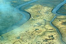
 Aerial view of Tutakoke Bird Camp, Coast of the Bering Sea just south of Hooper Bay, near Chevak, Alaska. | |
 Location within the U.S. state of Alaska | |
 Alaska's location within the U.S. | |
| Coordinates: 62°05′N 163°32′W / 62.09°N 163.53°W | |
| Country | |
| State | |
| Established | 1980[1][2] |
| Named for | Kusilvak Mountains |
| Largest city | Hooper Bay |
| Area | |
| • Total | 19,673 sq mi (50,950 km2) |
| • Land | 17,081 sq mi (44,240 km2) |
| • Water | 2,592 sq mi (6,710 km2) 13.2% |
| Population (2020) | |
| • Total | 8,278 |
| • Density | 0.44/sq mi (0.17/km2) |
| Time zone | UTC−9 (Alaska) |
| • Summer (DST) | UTC−8 (ADT) |
| Congressional district | At-large |
Kusilvak Census Area, formerly known as Wade Hampton Census Area, is a census area located in the U.S. state of Alaska. As of the 2020 census, the population was 8,368,[3] up from 7,459 in 2010.[4] It is part of the Unorganized Borough and therefore has no borough seat. Its largest community is the city of Hooper Bay, on the Bering Sea coast.
The census area's per capita income makes it the fourth-poorest county-equivalent in the United States.[citation needed] In 2014, it had the highest percentage of unemployed people of any county or census area in the United States, at 23.7 percent.[5]
- ^ In 1980, the United States Census Bureau divided the Unorganized Borough into 12 census areas.
- ^ Acquired its current name in 2015.
- ^ "2020 Census Data - Cities and Census Designated Places" (Web). State of Alaska, Department of Labor and Workforce Development. Retrieved October 31, 2021.
- ^ "State & County QuickFacts". United States Census Bureau. Archived from the original on May 19, 2014. Retrieved May 18, 2014.
- ^ "Labor Force Data by County, 2014 Annual Averages". U.S. Bureau of Labor Statistics. Retrieved July 27, 2015.