KutChap
กุดจับ | |
|---|---|
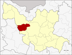
 District location in Udon Thani province | |
| Coordinates: 17°25′32″N 102°34′0″E / 17.42556°N 102.56667°E | |
| Country | Thailand |
| Province | Udon Thani |
| Seat | Mueang Phia |
| Area | |
• Total | 785.0 km2 (303.1 sq mi) |
| Population (2005) | |
• Total | 62,301 |
| • Density | 79.4/km2 (206/sq mi) |
| Time zone | UTC+7 (ICT) |
| Postal code | 41250 |
| Geocode | 4102 |
Kut Chap (Thai: กุดจับ, pronounced [kùt tɕàp]; Northeastern Thai: กุดจับ, pronounced [kǔt tɕǎp]) is a district (amphoe) in the western part of Udon Thani province, northeastern Thailand.