Kvikne Municipality
Kvikne herred | |
|---|---|
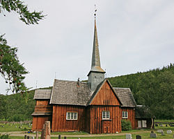
 View of the local Kvikne Church | |
 Hedmark within Norway | |
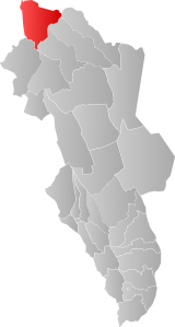
 Kvikne within Hedmark | |
| Coordinates: 62°34′56″N 10°17′14″E / 62.5823041986°N 10.28710781437°E | |
| Country | Norway |
| County | Hedmark |
| District | Østerdalen |
| Established | 1 Jan 1838 |
| • Created as | Formannskapsdistrikt |
| Disestablished | 1 Jan 1966 |
| • Succeeded by | Tynset and Rennebu |
| Administrative centre | Kvikne |
| Area (upon dissolution) | |
| • Total | 1,153 km2 (445 sq mi) |
| Population (1966) | |
| • Total | 1,084 |
| • Density | 0.94/km2 (2.4/sq mi) |
| Demonym | Kviknedøl[1] |
| Time zone | UTC+01:00 (CET) |
| • Summer (DST) | UTC+02:00 (CEST) |
| ISO 3166 code | NO-0440[2] |
Kvikne is a former municipality that was part of the old Hedmark county, Norway. The 1,153-square-kilometre (445 sq mi) municipality of Kvikne existed from 1838 until its dissolution in 1966 when it was split between the present-day municipalities of Tynset (in what is now Innlandet county) and Rennebu (in what is now Trøndelag county). The administrative centre of the municipality was the village of Kvikne where Kvikne Church is located.[3]
Copper mining and soapstone quarries were historically significant industries in the municipality.[3]
- ^ "Navn på steder og personer: Innbyggjarnamn" (in Norwegian). Språkrådet.
- ^ Bolstad, Erik; Thorsnæs, Geir, eds. (26 January 2023). "Kommunenummer". Store norske leksikon (in Norwegian). Kunnskapsforlaget.
- ^ a b Mæhlum, Lars, ed. (15 March 2021). "Kvikne". Store norske leksikon (in Norwegian). Kunnskapsforlaget. Retrieved 30 January 2022.