| Kyle Bay Sydney, New South Wales | |||||||||||||||
|---|---|---|---|---|---|---|---|---|---|---|---|---|---|---|---|
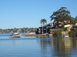
 Kyle Bay, view from Merriman Reserve | |||||||||||||||
 | |||||||||||||||
| Coordinates | 33°59′21″S 151°5′42″E / 33.98917°S 151.09500°E | ||||||||||||||
| Population | 1,039 (2021 census)[1] | ||||||||||||||
| Postcode(s) | 2221 | ||||||||||||||
| Elevation | 31 m (102 ft) | ||||||||||||||
| Location | 19 km (12 mi) south of Sydney CBD | ||||||||||||||
| LGA(s) | Georges River Council | ||||||||||||||
| State electorate(s) | Oatley | ||||||||||||||
| Federal division(s) | Cook | ||||||||||||||
| |||||||||||||||
Kyle Bay is a suburb in southern Sydney, in the state of New South Wales, Australia. Kyle Bay is 19 kilometres south of the Sydney central business district, in the local government area of the Georges River Council and is part of the St George area.
Kyle Bay takes its name from the bay that sits on the northern shore of the Georges River. It is a tiny, affluent, picturesque suburb around this bay and Harness Cask Point. Kyle Bay is surrounded by the suburbs of Blakehurst, South Hurstville and Connells Point. Kangaroo Point sits on the opposite bank of the Georges River. It is 7 km west of Botany Bay and 12 km north-west of the Cronulla surfing beaches. This leafy suburb is graced with scenic riverside parks and reserves including Merriman Reserve and Donnelly Reserve. Kyle Bay and Harness Cask Point are natural formations.
- ^ Australian Bureau of Statistics (28 June 2022). "Kyle Bay (State Suburb)". 2021 Census QuickStats. Retrieved 14 September 2024.
