| Kyle of Tongue National Scenic Area | |
|---|---|
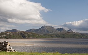
 Ben Loyal on the west side of Kyle of Tongue. | |
The location of the Kyle of Tongue within Sutherland. | |
| Location | Sutherland, Highland, Scotland |
| Coordinates | 58°28′37″N 4°27′11″W / 58.477°N 4.453°W |
| Area | 245 km2 (95 sq mi)[1] |
| Established | 1981 |
| Governing body | NatureScot |
The Kyle of Tongue (Scottish Gaelic: Caol Thunga) is a shallow sea loch[2] in northwest Highland, Scotland, in the western part of Sutherland. Featuring a rocky coastline, its mouth is formed at Tongue Bay. The community of Tongue is situated on the Kyle's eastern shore and the loch is crossed by the Kyle of Tongue Bridge and Causeway.
The sea loch and surrounding countryside is designated as the Kyle of Tongue National Scenic Area, one of the forty such areas in Scotland, which are defined so as to identify areas of exceptional scenery and to ensure its protection from inappropriate development.[3] The designated area covers 24,488 ha in total, of which 21,093 ha is on land, with a further 3396 ha being marine (i.e. below low tide level),[1] and takes in the nearby mountains of Ben Hope and Ben Loyal as well as several small islands and the coastline as far east as Bettyhill.[4]
- ^ a b "National Scenic Areas - Maps". SNH. 20 December 2010. Archived from the original on 12 June 2018. Retrieved 4 March 2018.
- ^ Smith, Robin; Lawson, Alan (2001). The making of Scotland: a comprehensive guide to the growth of its cities, towns, and villages. Canongate U.S. pp. 904–. ISBN 978-1-84195-170-6. Retrieved 29 December 2011.
- ^ "National Scenic Areas". NatureScot. Retrieved 5 October 2020.
- ^ "Kyle of Tongue National Scenic Area". NatureScot. Retrieved 5 October 2020.
