You can help expand this article with text translated from the corresponding article in Japanese. Click [show] for important translation instructions.
|
Native name: 九州 | |
|---|---|
 October 2009 NASA satellite image of Kyushu | |
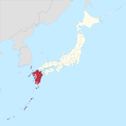
 Kyushu region of Japan and the current prefectures on the island of Kyushu | |
| Geography | |
| Location | East Asia |
| Coordinates | 33°N 131°E / 33°N 131°E |
| Archipelago | Japanese Archipelago |
| Area | 36,782.37[1] km2 (14,201.75 sq mi) |
| Area rank | 37th |
| Coastline | 12,221 km (7593.8 mi) |
| Highest elevation | 1,791 m (5876 ft) |
| Highest point | Mount Kujū[2] |
| Administration | |
| Prefectures | |
| Largest settlement | Fukuoka |
| Demographics | |
| Population | 12,650,847 (as of June 2022) |
| Pop. density | 307.13/km2 (795.46/sq mi) |
| Ethnic groups | Japanese |
| Additional information | |
| Time zone | |
 | |
Kyūshū (九州, Kyūshū, pronounced [kʲɯꜜːɕɯː] , lit. 'Nine Provinces') is the third-largest island of Japan's four main islands and the most southerly of the four largest islands (i.e. excluding Okinawa and the other Ryukyu (Nansei) Islands).[3][4] In the past, it has been known as Kyūkoku (九国, "Nine Countries"), Chinzei (鎮西, "West of the Pacified Area") and Tsukushi-no-shima (筑紫島, "Island of Tsukushi"). The historical regional name Saikaidō (西海道, lit. West Sea Circuit) referred to Kyushu and its surrounding islands. Kyushu has a land area of 36,782 square kilometres (14,202 sq mi) and a population of 14,311,224 in 2018.[5]
In the 8th-century Taihō Code reforms, Dazaifu was established as a special administrative term for the region.[6]
- ^ Cite error: The named reference
island1was invoked but never defined (see the help page). - ^ "Kujū-san, Japan". Peakbagger.com.
- ^ "離島とは(島の基礎知識) (what is a remote island?)". MLIT (Ministry of Land, Infrastructure, Transport and Tourism) (in Japanese). Ministry of Land, Infrastructure, Transport and Tourism. 22 August 2015. Archived from the original (website) on 2007-11-13. Retrieved 9 August 2019.
MILT classification 6,852 islands(main islands: 5 islands, remote islands: 6,847 islands)
- ^ Nussbaum, Louis-Frédéric. (2005). "Kyūshū" in Japan Encyclopedia, p. 588, p. 588, at Google Books
- ^ Cite error: The named reference
thoughtcowas invoked but never defined (see the help page). - ^ Nussbaum, "Dazaifu" in p. 150, p. 150, at Google Books; Dazaifu