L'Isle-en-Dodon
L'Isla de Haut (Occitan) | |
|---|---|
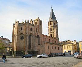
 The church in L'Isle-en-Dodon | |
| Coordinates: 43°22′56″N 0°50′10″E / 43.3822°N 0.8361°E | |
| Country | France |
| Region | Occitania |
| Department | Haute-Garonne |
| Arrondissement | Saint-Gaudens |
| Canton | Cazères |
| Government | |
| • Mayor (2020–2026) | Lionel Welter[1] |
| Area 1 | 22.58 km2 (8.72 sq mi) |
| Population (2021)[2] | 1,628 |
| • Density | 72/km2 (190/sq mi) |
| Time zone | UTC+01:00 (CET) |
| • Summer (DST) | UTC+02:00 (CEST) |
| INSEE/Postal code | 31239 /31230 |
| Elevation | 187–326 m (614–1,070 ft) (avg. 200 m or 660 ft) |
| 1 French Land Register data, which excludes lakes, ponds, glaciers > 1 km2 (0.386 sq mi or 247 acres) and river estuaries. | |
L'Isle-en-Dodon (French pronunciation: [l il ɑ̃ dɔdɔ̃]; Occitan: L'Isla de Haut) is a commune in the Haute-Garonne department in southwestern France. The commune has the short border with the neighbouring department, Gers.
The rugby team is the focal point of the community. Based in the municipal stadium it regularly attracts 1000 spectators and regularly qualifies for the last 32 and beyond in the Federale 3 playoffs
- ^ "Répertoire national des élus: les maires" (in French). data.gouv.fr, Plateforme ouverte des données publiques françaises. 13 September 2022.
- ^ "Populations légales 2021" (in French). The National Institute of Statistics and Economic Studies. 28 December 2023.


