LaVale, Maryland | |
|---|---|
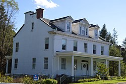
 Four Mile House (c. 1840), one of the inns on the National Road | |
 Location of LaVale, Maryland | |
| Coordinates: 39°39′17″N 78°48′46″W / 39.65472°N 78.81278°W | |
| Country | |
| State | |
| County | |
| Area | |
| • Total | 9.12 sq mi (23.61 km2) |
| • Land | 9.11 sq mi (23.60 km2) |
| • Water | 0.00 sq mi (0.01 km2) |
| Elevation | 784 ft (239 m) |
| Population (2020) | |
| • Total | 4,201 |
| • Density | 460.99/sq mi (177.99/km2) |
| Time zone | UTC−5 (Eastern (EST)) |
| • Summer (DST) | UTC−4 (EDT) |
| ZIP codes | 21502, 21504 |
| Area code(s) | 301, 240 |
| FIPS code | 24-46075 |
| GNIS feature ID | 0590618 |
LaVale is a census-designated place (CDP) in Allegany County, Maryland, United States. It is part of the Cumberland, MD-WV Metropolitan Statistical Area. The population was 4,201 as of the 2020 census.[2]
- ^ "2020 U.S. Gazetteer Files". United States Census Bureau. Retrieved April 26, 2022.
- ^ "Explore Census Data". data.census.gov. Retrieved 2024-02-01.