You can help expand this article with text translated from the corresponding article in French. (December 2008) Click [show] for important translation instructions.
|
La Flotte | |
|---|---|
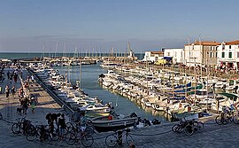
 The harbour in La Flotte | |
| Coordinates: 46°11′16″N 1°19′28″W / 46.1878°N 1.3244°W | |
| Country | France |
| Region | Nouvelle-Aquitaine |
| Department | Charente-Maritime |
| Arrondissement | La Rochelle |
| Canton | Île de Ré |
| Intercommunality | Île de Ré |
| Government | |
| • Mayor (2020–2026) | Jean-Paul Heraudeau[1] |
| Area 1 | 12.32 km2 (4.76 sq mi) |
| Population (2021)[2] | 3,017 |
| • Density | 240/km2 (630/sq mi) |
| Demonym(s) | Flottais, Flottaises |
| Time zone | UTC+01:00 (CET) |
| • Summer (DST) | UTC+02:00 (CEST) |
| INSEE/Postal code | 17161 /17630 |
| Elevation | 0–17 m (0–56 ft) (avg. 8 m or 26 ft) |
| 1 French Land Register data, which excludes lakes, ponds, glaciers > 1 km2 (0.386 sq mi or 247 acres) and river estuaries. | |
La Flotte (French pronunciation: [la flɔt]; sometimes locally La Flotte-en-Re), is a commune on the isle of Ré off the western coast of France, administratively part of the department of Charente-Maritime within the larger Nouvelle-Aquitaine region.[3]
It is the largest municipality on the Île de Ré by area, and the second largest by population, second to Sainte-Marie-de-Ré on the southern tip of the island.
La Flotte was declared one of the most beautiful villages in France by the eponymous independent tourism organization Les Plus Beaux Villages de France, and since 2011, the town has been a part of the departmental government's "Stone and Water Villages" tourism initiative to promote notable coastal and waterfront locales (i.e., where the stone (city) meets the water (sea, river etc.).
- ^ "Répertoire national des élus: les maires". data.gouv.fr, Plateforme ouverte des données publiques françaises (in French). 9 August 2021.
- ^ "Populations légales 2021" (in French). The National Institute of Statistics and Economic Studies. 28 December 2023.
- ^ Commune de La Flotte (17161), INSEE


