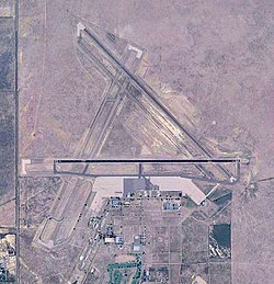
La Junta Municipal Airport (former La Junta Army Air Field) | |||||||||||||||
|---|---|---|---|---|---|---|---|---|---|---|---|---|---|---|---|
 USGS 2006 orthophoto | |||||||||||||||
| Summary | |||||||||||||||
| Airport type | Public | ||||||||||||||
| Owner | City of La Junta | ||||||||||||||
| Serves | La Junta, Colorado | ||||||||||||||
| Location | Otero County, Colorado | ||||||||||||||
| Elevation AMSL | 4,229 ft / 1,289 m | ||||||||||||||
| Coordinates | 38°03′00″N 103°30′35″W / 38.05000°N 103.50972°W | ||||||||||||||
| Map | |||||||||||||||
| Runways | |||||||||||||||
| |||||||||||||||
| Helipads | |||||||||||||||
| |||||||||||||||
| Statistics (2010) | |||||||||||||||
| |||||||||||||||
La Junta Municipal Airport (ICAO: KLHX, FAA LID: LHX) is three miles north of La Junta, in Otero County, Colorado, United States.[1] The National Plan of Integrated Airport Systems for 2011–2015 categorized it as a general aviation facility.[2]
Many U.S. airports use the same three-letter location identifier for the FAA and IATA, but this airport is LHX to the FAA[1] and has no IATA code.[3][4]
- ^ a b c FAA Airport Form 5010 for LHX PDF. Federal Aviation Administration. Effective November 15, 2012.
- ^ "2011–2015 NPIAS Report, Appendix A" (PDF). National Plan of Integrated Airport Systems]. Federal Aviation Administration. October 4, 2010. Archived from the original (PDF, 2.03 MB) on September 27, 2012.
- ^ "La Junta Municipal Airport (IATA: none, ICAO: KLHX, FAA: LHX)". Great Circle Mapper. Retrieved June 22, 2013.
- ^ "IATA Airport Code Search (LHX)". International Air Transport Association. Retrieved June 22, 2013.


