La Minerve | |
|---|---|
 Lake Marie-Louise in La Minerve | |
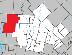
 Location within Les Laurentides RCM | |
| Coordinates: 46°15′N 74°56′W / 46.250°N 74.933°W[1] | |
| Country | Canada |
| Province | Quebec |
| Region | Laurentides |
| RCM | Les Laurentides |
| Settled | 1885 |
| Constituted | December 30, 1892 |
| Government | |
| • Mayor | Johnny Salera |
| • Federal riding | Laurentides—Labelle |
| • Prov. riding | Labelle |
| Area | |
• Total | 328.10 km2 (126.68 sq mi) |
| • Land | 274.92 km2 (106.15 sq mi) |
| Population (2021)[3] | |
• Total | 1,421 |
| • Density | 5.2/km2 (13/sq mi) |
| • Pop (2016-21) | |
| • Dwellings | 1,638 |
| Time zone | UTC−5 (EST) |
| • Summer (DST) | UTC−4 (EDT) |
| Postal code(s) | |
| Area code | 819 |
| Highways | No major routes |
| Website | www.municipalite. laminerve.qc.ca |
La Minerve (French pronunciation: [la minɛʁv]) is a village and municipality in the Laurentides region of Quebec, Canada, part of the Les Laurentides Regional County Municipality.
Located in the Laurentian Mountains, La Minerve is still fairly forested and covered with many lakes, notably Chapleau, Désert, and La Minerve Lakes. Its southern portion is part of the Papineau-Labelle Wildlife Reserve. The area is popular for cottage vacationing. In the summer, the small local population swells with nearly 15,000 tourists.[4]
- ^ Cite error: The named reference
toponymiewas invoked but never defined (see the help page). - ^ a b Cite error: The named reference
mamrotwas invoked but never defined (see the help page). - ^ a b Cite error: The named reference
sc2021was invoked but never defined (see the help page). - ^ Cite error: The named reference
MunLMwas invoked but never defined (see the help page).
