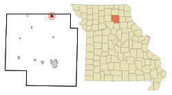
La Plata, Missouri | |
|---|---|
 Downtown La Plata | |
 Location within Macon County and Missouri | |
| Coordinates: 40°01′27″N 92°29′29″W / 40.02417°N 92.49139°W | |
| Country | United States |
| State | Missouri |
| County | Macon |
| Area | |
• Total | 1.59 sq mi (4.13 km2) |
| • Land | 1.59 sq mi (4.11 km2) |
| • Water | 0.01 sq mi (0.02 km2) |
| Elevation | 938 ft (286 m) |
| Population | |
• Total | 1,257 |
| • Density | 791.56/sq mi (305.53/km2) |
| Time zone | UTC-6 (Central (CST)) |
| • Summer (DST) | UTC-5 (CDT) |
| ZIP code | 63549 |
| Area code | 660 |
| FIPS code | 29-40682 [4] |
| GNIS feature ID | 2395569[2] |
| Website | www |
La Plata is a city in Macon County, Missouri, United States. The population was 1,257 at the 2020 census,[5] down from 1,366 in 2010. La Plata is located next to the Adair County line and is on a mainline of the BNSF Railway. The town is best known for La Plata station, which provides passenger rail service to Chicago and Los Angeles.
- ^ "2023 U.S. Gazetteer Files: Missouri". United States Census Bureau. Retrieved March 15, 2024.
- ^ a b U.S. Geological Survey Geographic Names Information System: La Plata, Missouri
- ^ "P1. Race – La Plata city, Missouri: 2020 DEC Redistricting Data (PL 94-171)". U.S. Census Bureau. Retrieved March 15, 2024.
- ^ "U.S. Census website". United States Census Bureau. Retrieved January 31, 2008.
- ^ "Explore Census Data". data.census.gov. Retrieved February 1, 2022.