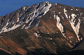
| La Plata Peak | |
|---|---|
 | |
| Highest point | |
| Elevation | 14,343 ft (4372 m)[1] NAVD88 |
| Prominence | 1836 ft (560 m)[1] |
| Isolation | 6.28 mi (10.11 km)[1] |
| Listing | |
| Coordinates | 39°01′46″N 106°28′22″W / 39.0293524°N 106.4729047°W[2] |
| Geography | |
| Location | Chaffee County, Colorado, U.S.[2] |
| Parent range | Sawatch Range, Collegiate Peaks[1] |
| Topo map(s) | USGS 7.5' topographic map Mount Elbert, Colorado[2] |
| Climbing | |
| First ascent | July 26, 1873 Hayden Survey |
| Easiest route | Northwest Ridge or Southwest Ridge: Hike (class 2) |
La Plata Peak is the fifth-highest summit of the Rocky Mountains of North America and the U.S. state of Colorado. The prominent 14,343-foot (4,372 m) fourteener is located in the Collegiate Peaks Wilderness of San Isabel National Forest, 22.7 miles (36.5 km) northwest by west (bearing 308°) of the Town of Buena Vista in Chaffee County, Colorado, United States.[a][1][2]
"La Plata" is Spanish for "The Silver", a reference to the many silver deposits in the area. The nearby ghost towns of Winfield and Hamilton were prominent silver mining towns in the early part of the 20th century. A Hayden Survey team first climbed the peak on July 26, 1873.[3]
The elevation of 14,361 feet marked on the USGS Mount Elbert Quadrangle is incorrect, and should read 14,336 feet (in the NGVD 29 vertical datum).[4]
- ^ a b c d e "La Plata Peak, Colorado". Peakbagger.com. Retrieved January 2, 2016.
- ^ a b c d "La Plata Peak". Geographic Names Information System. United States Geological Survey, United States Department of the Interior. Retrieved October 20, 2014.
- ^ "La Plata Peak". SummitPost.org. Retrieved 2008-11-30.
- ^ Gerry Roach (1999). Colorado's Fourteeners: From Hikes to Climbs. Fulcrum Publishing. pp. 98–. ISBN 978-1-55591-412-7.
Cite error: There are <ref group=lower-alpha> tags or {{efn}} templates on this page, but the references will not show without a {{reflist|group=lower-alpha}} template or {{notelist}} template (see the help page).
