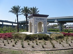
City of La Porte | |
|---|---|
 Welcome to La Porte | |
| Nickname: "L.P." | |
 Location in Harris County and the state of Texas | |
| Coordinates: 29°39′53″N 95°2′27″W / 29.66472°N 95.04083°W | |
| Country | United States |
| State | Texas |
| County | Harris |
| Government | |
| • Type | Council-Manager |
| • Mayor | Louis R. Rigby |
| • City Council | List |
| • City Manager | Corby Alexander |
| Area | |
| • Total | 19.90 sq mi (51.55 km2) |
| • Land | 18.60 sq mi (48.18 km2) |
| • Water | 1.30 sq mi (3.36 km2) |
| Elevation | 20 ft (6 m) |
| Population (2020) | |
| • Total | 35,124 |
| • Density | 1,880.03/sq mi (725.90/km2) |
| Time zone | UTC-6 (Central (CST)) |
| • Summer (DST) | UTC-5 (CDT) |
| ZIP codes | 77571-77572 |
| Area codes | 713, 281, 832, 346 |
| FIPS code | 48-41440[2] |
| GNIS feature ID | 2411580[3] |
| Website | Official website |
La Porte (/lə ˈpɔːrt/ lə PORT) is a city in Harris County, Texas, United States, within the Bay Area of the Houston–Sugar Land–Baytown metropolitan area. As of the 2020 census, the city population was 35,124.[4] La Porte is the fourth-largest incorporated city in Harris County.
When La Porte celebrated its centennial in 1992, it was the home of Barbours Cut Terminal, operated by the Port of Houston Authority since 1977. Fifteen years later, the Port of Houston's newest addition, Bayport Terminal, was established just south of La Porte. The area around La Porte has served an increasingly important role in international trade since the 1970s.
The area around modern La Porte gained fame early in Texas history as the location of the Battle of San Jacinto on April 21, 1836, which ended the Texas Revolution, establishing the independence of the Republic of Texas from Mexico. The San Jacinto Monument, in the unincorporated area of La Porte, commemorates the battle. During the early 20th century, particularly the 1920s and 1930s, La Porte's Sylvan Beach became a nationally known tourist destination attracting some of the nation's most well-known entertainers. As a result of changing economics in the Houston area and beach erosion, the tourist business declined while industrial development in the area grew. During World War II and afterward, La Porte's economy rapidly shifted toward petroleum/petrochemicals and shipping, which developed as the dominant industries in the Pasadena-Baytown area.
- ^ "2019 U.S. Gazetteer Files". United States Census Bureau. Retrieved August 7, 2020.
- ^ "U.S. Census website". United States Census Bureau. Retrieved January 31, 2008.
- ^ U.S. Geological Survey Geographic Names Information System: City of La Porte
- ^ "Profile of General Population and Housing Characteristics: 2010 Demographic Profile Data (DP-1): La Porte city, Texas". United States Census Bureau. Retrieved June 15, 2012.