You can help expand this article with text translated from the corresponding article in French. (June 2020) Click [show] for important translation instructions.
|
La Rochelle
La Rochéle (Poitevin–Saintongeais) | |
|---|---|
Prefecture and commune | |
| Coordinates: 46°10′N 1°09′W / 46.16°N 1.15°W | |
| Country | France |
| Region | Nouvelle-Aquitaine |
| Department | Charente-Maritime |
| Arrondissement | La Rochelle |
| Intercommunality | CA La Rochelle |
| Government | |
| • Mayor (2020–2026) | Jean-François Fountaine[1] |
| Area 1 | 28.43 km2 (10.98 sq mi) |
| Population (2021)[2] | 78,535 |
| • Density | 2,800/km2 (7,200/sq mi) |
| Time zone | UTC+01:00 (CET) |
| • Summer (DST) | UTC+02:00 (CEST) |
| INSEE/Postal code | 17300 /17000 |
| Elevation | 0–28 m (0–92 ft) (avg. 4 m or 13 ft) |
| 1 French Land Register data, which excludes lakes, ponds, glaciers > 1 km2 (0.386 sq mi or 247 acres) and river estuaries. | |
La Rochelle (UK: /ˌlæ rɒˈʃɛl/, US: /ˌlɑː roʊˈʃɛl/, French: [la ʁɔʃɛl] ; Poitevin-Saintongeais: La Rochéle) is a city on the west coast of France and a seaport on the Bay of Biscay, a part of the Atlantic Ocean. It is the capital of the Charente-Maritime department. With 78,535 inhabitants in 2021, La Rochelle is the most populated commune in the department and ranks fourth in the Nouvelle-Aquitaine region after Bordeaux, the regional capital, Limoges and Poitiers.
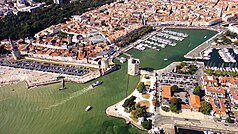
Situated on the edge of the Atlantic Ocean the city is connected to the Île de Ré by a 2.9-kilometre-long (1+3⁄4-mile) bridge completed on 19 May 1988. Since the Middle Ages the harbour has opened onto a protected strait, the Pertuis d'Antioche and is regarded as a "Door océane" or gateway to the ocean because of the presence of its three ports (fishing, trade and yachting). The city has a strong commercial tradition, having an active port from very early on in its history.
The city traces its origins to the Gallo-Roman period, attested by the remains of important salt marshes and villas. The Dukes of Aquitaine granted it a charter as a free port in 1130. With the opening of the English market following the second marriage of Eleanor of Aquitaine in 1152, the presence of the Knights Templar and the Knights of Saint John of Jerusalem quickly made this small town the largest port on the Atlantic.[3]
To this day, the city still possesses a rich historical fabric, including the Saint-Nicholas tower, and an urban heritage. The capital of Aunis, it has become the most important coastal city between the Loire and Gironde estuaries. La Rochelle's urban activities are many in number and strongly differentiated, being a city with port and industrial functions that are still important, but also including a predominantly administrative and tertiary sector that is reinforced by the university and a rapidly developing tourism industry. In the early 21st century, the city has consistently been ranked among France's most liveable cities.[4] Until 2015, the town was part of the administrative region called Poitou-Charentes, that was before the delimitation of regions in France.[5]
- ^ "Répertoire national des élus: les maires" (in French). data.gouv.fr, Plateforme ouverte des données publiques françaises. 13 September 2022.
- ^ "Populations légales 2021" (in French). The National Institute of Statistics and Economic Studies. 28 December 2023.
- ^ Favreau, Robert (1986). "La Rochelle, port français sur l'Atlantique au XIIIe siècle". Actes des congrès de la Société des historiens médiévistes de l'enseignement supérieur public. 17 (1): 49–76. doi:10.3406/shmes.1986.1451.
- ^ "La Rochelle classée troisième ville de France la plus agréable à vivre". actu.fr (in French). 20 January 2020. Retrieved 13 November 2020.
- ^ "LOI No. 2015-29 of 16 January 2015 on the delimitation of the regions, regional and departmental elections and amending the electoral calendar" [LOI n° 2015-29 du 16 janvier 2015 relative à la délimitation des régions, aux élections régionales et départementales et modifiant le calendrier électoral (1)]. legifrance.gouv.fr. 18 January 2015. Retrieved 14 August 2024.


