Laarbeek | |
|---|---|
 | |
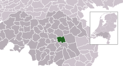
 Location in North Brabant | |
| Coordinates: 51°32′N 5°38′E / 51.533°N 5.633°E | |
| Country | Netherlands |
| Province | North Brabant |
| Established | 1 January 1997[1] |
| Government | |
| • Body | Municipal council |
| • Mayor | Frank van der Meijden (CDA) |
| Area | |
| • Total | 56.17 km2 (21.69 sq mi) |
| • Land | 55.35 km2 (21.37 sq mi) |
| • Water | 0.82 km2 (0.32 sq mi) |
| Elevation | 14 m (46 ft) |
| Population (January 2021)[5] | |
| • Total | 22,805 |
| • Density | 412/km2 (1,070/sq mi) |
| Time zone | UTC+1 (CET) |
| • Summer (DST) | UTC+2 (CEST) |
| Postcode | 5735–5741 |
| Area code | 0492, 0499 |
| Website | www |
Laarbeek (Dutch pronunciation: [ˈlaːrbeːk] ) is a municipality located in the province of North Brabant in the south of the Netherlands. It was formed in 1997 from the former municipalities Beek en Donk, Aarle-Rixtel and Lieshout (which included the village Mariahout). Laarbeek is part of the city region 'Samenwerkingsverband Regio Eindhoven', centered on the city of Eindhoven. The town hall is located in Beek en Donk.
Lieshout is home of the Bavaria Brewery, one of the Netherlands' largest breweries which produces for local and foreign markets.
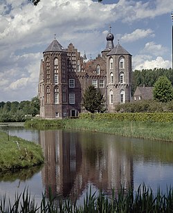
The Croy Castle is located near the village Aarle-Rixtel.
- ^ "Gemeentelijke indeling op 1 januari 1997" [Municipal divisions on 1 January 1997]. cbs.nl (in Dutch). CBS. Retrieved 29 May 2014.
- ^ "Burgemeester Frank van der Meijden" [Frank van der Meijden] (in Dutch). Gemeente Laarbeek. Archived from the original on 28 January 2015. Retrieved 24 January 2015.
- ^ "Kerncijfers wijken en buurten 2020" [Key figures for neighbourhoods 2020]. StatLine (in Dutch). CBS. 24 July 2020. Retrieved 19 September 2020.
- ^ "Postcodetool for 5741GA". Actueel Hoogtebestand Nederland (in Dutch). Het Waterschapshuis. Archived from the original on 21 September 2013. Retrieved 29 May 2014.
- ^ "Bevolkingsontwikkeling; regio per maand" [Population growth; regions per month]. CBS Statline (in Dutch). CBS. 1 January 2021. Retrieved 2 January 2022.
