Labrador | |
|---|---|
| Nickname: "The Big Land" | |
| Motto: Munus splendidum mox explebitur (Latin for 'Our splendid task will soon be fulfilled') | |
| Anthem: "Ode to Labrador" | |
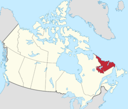
 Labrador (red) within Canada | |
| Coordinates: 54°N 62°W / 54°N 62°W | |
| Country | Canada |
| Province | Newfoundland and Labrador |
| Ceded to Great Britain by the Treaty of Paris | 1763 |
| Became part of the Province of Lower Canada | 1791 |
| Transferred to Newfoundland Colony | 1809 |
| Area | |
| • Total | 294,330 km2 (113,640 sq mi) |
| Population (2021) | |
| • Total | 26,655 |
| • Density | 0.091/km2 (0.23/sq mi) |
| Time zones | UTC−4 (AST) |
| • Summer (DST) | UTC−3 (ADT) |
| UTC−3:30 (NST) | |
| • Summer (DST) | UTC−2:30 (NDT) |
| MP | 1 |
| MHA | 4 |
| Ethnic groups | English, Innu,[1] Inuit, Métis |
Labrador (/ˈlæbrədɔːr/ LAB-rə-dor) is a geographic and cultural region within the Canadian province of Newfoundland and Labrador.[2] It is the primarily continental portion of the province and constitutes 71% of the province's area but is home to only 6% of its population. It is separated from the island of Newfoundland by the Strait of Belle Isle. It is the largest and northernmost geographical region in the four Atlantic provinces.[3]
Labrador occupies most of the eastern part of the Labrador Peninsula. It is bordered to the west and south by the province of Quebec. Labrador also shares a small land border with the territory of Nunavut on Killiniq Island.
The indigenous peoples of Labrador include the Northern Inuit of Nunatsiavut, the Southern Métis of NunatuKavut, and the Innu of Nitassinan.[1][4]
- ^ a b Cite error: The named reference
Impacts of Non-Indigenous Activities on the Innuwas invoked but never defined (see the help page). - ^ "Labrador peninsula (Toponymy)". Gouvernement of Quebec (in French). Commission de Toponymy Quebec. 18 June 1993. Retrieved 31 August 2024.
Over the years, many variations have been used: Terraagricule (1558); Land of Labor (1575); Estotilandt (1597) or Estotilande (1656); Terra Cortereale (1597); New Britain (1656).
- ^ Fabien Caron (1965). "Albert Peter Low and the exploration of Quebec-Labrador" (PDF). Érudit (in English and French). Center for Nordic Studies, Laval University. p. 16. Retrieved 23 August 2024.
... he had the consuming curiosity of the born explorer which must always see the other side of the hill or the other end of the river.
- ^ Wadden, Marie (December 1991). Nitassinan: The Innu Struggle to Reclaim Their Homeland. Douglas & McIntyre. p. 240. ISBN 978-1-55365-731-6. Archived from the original on 2013-01-21. Retrieved 2012-11-19.
