| Lac la Plonge | |
|---|---|
 | |
| Location | Saskatchewan |
| Coordinates | 55°08′N 107°20′W / 55.133°N 107.333°W |
| Primary outflows | Rivière la Plonge |
| Basin countries | Canada |
| Max. depth | 65 m (213 ft) |
| Shore length1 | 109.8 km (68.2 mi) |
| Surface elevation | 466 m (1,529 ft)[1] |
| Islands |
|
| Settlements | Lac La Plonge |
| 1 Shore length is not a well-defined measure. | |
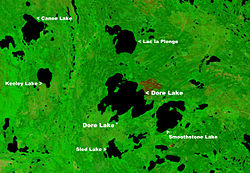
Lac la Plonge[2] is a glacial lake in the Canadian province of Saskatchewan in the basin of the Beaver River, near Lac Île-à-la-Crosse. It is located in the boreal forest near the Canadian Shield. On the lake's northern shore, the community of Lac La Plonge, a resort, and campgrounds are accessed via Highway 165.[3]
The Rivière la Plonge,[4] Lac la Plonge's outflow, flows west from the north-west section of the lake into Beaver River at Beauval.[5] The lake's outflow is the site of the Lac La Plonge Dam, which is operated by the Saskatchewan Water Security Agency.[6]
- ^ "Lac la Plonge topographic map". topographic-map.com. World Topographic Map. Retrieved 13 March 2024.
- ^ "Lac la Plonge". Canadian Geographical Names Database. Government of Canada. Retrieved 12 March 2024.
- ^ "Lac La Plonge Fishing Map". GPS Nautical Charts. Bist LLC. Retrieved 13 March 2024.
- ^ "Rivière la Plonge". Canadian Geographical Names Database. Government of Canada. Retrieved 13 March 2024.
- ^ "Lac la Plonge". Sask Lakes. Retrieved 13 March 2024.
- ^ "Dam on a river (Lac la Plonge)". Virtual Museum of Metis History and Culture. Gabriel Dumont Institute of Native Studies and Applied Research. Retrieved 13 March 2024.

