Ladd's Addition Historic District | |
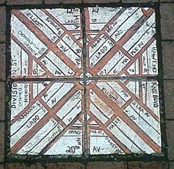
 Brick map of Ladd's Addition that was at the corner of SE 34th Avenue and SE Madison Street until roughly 2018. | |
| Location | Portland, Oregon |
|---|---|
| Coordinates | 45°30′31″N 122°38′58″W / 45.508539°N 122.649413°W |
| Area | 126 acres (0.51 km2) |
| Built | 1905–1930[1] |
| MPS | [a] |
| NRHP reference No. | 88001310 |
| Added to NRHP | August 31, 1988 |
Ladd's Addition is an inner southeast historic district of Portland, Oregon, United States. It is Portland's oldest planned residential development, and one of the oldest in the western United States.[1] The district is known in Portland for a diagonal street pattern, which is at odds with the rectilinear grid of the surrounding area. Roughly eight blocks (east-west) by ten blocks (north-south) in size (by reference to the surrounding grid), Ladd's is bordered by SE Hawthorne, Division, 12th, and 20th streets. It is part of the Hosford-Abernethy neighborhood association.
- ^ a b Cite error: The named reference
npswas invoked but never defined (see the help page). - ^ McClelland, Linda Flint; Ames, David L.; Pope, Sarah Dillard (December 22, 2004), National Register of Historic Multiple Property Documentation Form: Historic Residential Suburbs in the United States, 1830–1960 (PDF), retrieved December 23, 2016.
Cite error: There are <ref group=lower-alpha> tags or {{efn}} templates on this page, but the references will not show without a {{reflist|group=lower-alpha}} template or {{notelist}} template (see the help page).