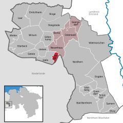
Lage | |
|---|---|
Location of Lage within Grafschaft Bentheim district  | |
| Coordinates: 52°28′02″N 06°57′37″E / 52.46722°N 6.96028°E | |
| Country | Germany |
| State | Lower Saxony |
| District | Grafschaft Bentheim |
| Municipal assoc. | Neuenhaus |
| Government | |
| • Mayor | Henni Nyhuis |
| Area | |
| • Total | 6.39 km2 (2.47 sq mi) |
| Elevation | 19 m (62 ft) |
| Population (2022-12-31)[1] | |
| • Total | 1,027 |
| • Density | 160/km2 (420/sq mi) |
| Time zone | UTC+01:00 (CET) |
| • Summer (DST) | UTC+02:00 (CEST) |
| Postal codes | 49828 |
| Dialling codes | 0 59 41 |
| Vehicle registration | NOH |
| Website | www.herrlichkeit-lage.de |
Lage is a community on the river Dinkel in the district of Grafschaft Bentheim in Lower Saxony with roughly 1,000 inhabitants. It belongs to the Joint Community (Samtgemeinde) of Neuenhaus.
Of particular sightseeing interest are the church, built in 1687, the watermill, built in 1270, the castle ruins (first mentioned in a document in 1183, destroyed in 1324–1326 and 1626), the lordly manor, built in 1686 and the historic Oak Avenue with the manor staff’s old houses.
The extended name Herrlichkeit Lage – “Herrlichkeit” means grandness or magnificence – refers to the time between the end of the Thirty Years' War and the year 1803, in which Lage was a self-standing small state with its own jurisdiction.
The biggest club is the sport club, Rot-Weiß Lage 29 e. V. (about 700 members).

