| Lahontan Valley | |
|---|---|
| Lahontan Basin | |
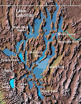
 The Lahontan Valley is adjacent to the Carson Sink and southwest of the Humboldt Sink. | |
| Floor elevation | 4,006 ft (1,221 m)[1] |
| Geography | |
| Country | United States |
| State | Nevada |
| District | Churchill County |
| Coordinates | 39°34′0″N 118°50′0″W / 39.56667°N 118.83333°W |
| Traversed by | U.S. Route 50 |
The Lahontan Valley is a basin in Churchill County, Nevada, United States.[1] The valley is a landform of the central portion of the prehistoric Lake Lahontan's lakebed of 20,000-9,000 years ago. The valley and the adjacent Carson Sink represent a small portion of the lake bed. Humboldt Lake is to the valley's northeast. Pyramid Lake is west. Walker Lake is to the south. The valley is part of the larger Great Basin Desert, however during the California Gold Rush the valley was often called the Forty Mile Desert.

