| Lake Bosumtwi | |
|---|---|
 | |
| Location | Ashanti |
| Coordinates | 06°30′20″N 01°24′33″W / 6.50556°N 1.40917°W |
| Type | Ancient lake, Impact crater lake 1.07 million years old[1] |
| Primary inflows | rainfall[2] |
| Primary outflows | none[2] |
| Catchment area | 400 km2 (150 sq mi)[2] |
| Basin countries | Ghana |
| Max. length | 8.6 km (5.3 mi) |
| Max. width | 8.1 km (5.0 mi) |
| Surface area | 49 km2 (19 sq mi)[2] |
| Average depth | 45 m (148 ft)[2] |
| Max. depth | 81 m (266 ft)[2] |
| Surface elevation | 150 m (490 ft) |
| References | [2] |
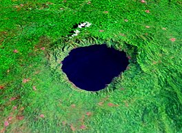
Lake Bosumtwi is the only natural lake in Ghana. It is situated within an ancient impact crater that is about 10.5 kilometres (6.5 mi) in diameter.[2] It is about 30 km (19 mi) south-east of Kumasi, the capital of Ashanti, and is a popular recreational area. There are about 30 villages near the crater lake of Lake Bosumtwi, with a combined population of about 70,000.[3] The most popular amongst the villages where tourists usually settle is Abono.[4]
The Ashanti consider Bosumtwi a sacred lake. According to traditional belief, the souls of the dead come here to bid farewell to the goddess Asase Ya. Because of this, it is considered permissible to fish in the lake only from wooden planks. Among the fish species in the lake is the endemic cichlid Hemichromis frempongi, and the near-endemic cichlids Tilapia busumana and T. discolor.[5][6][7]
- ^ Cite error: The named reference
EIDBwas invoked but never defined (see the help page). - ^ a b c d e f g h "Bosumtwi". LakeNet. Retrieved 2007-02-18.
- ^ "Lake Bosomtwi". touringghana.com. 2016-03-27. Retrieved 2019-06-08.
- ^ Adom, Dickson (2018-01-01). "The human impact and the aquatic biodiversity of lake Bosomtwe: rennaisance (sic) of the cultural traditions of Abono (Ghana)?". Transylvanian Review of Systematical and Ecological Research. 20 (1): 87–110. doi:10.1515/trser-2018-0007. ISSN 2344-3219.
- ^ Froese, Rainer; Pauly, Daniel (eds.). "Hemichromis frempongi". FishBase. February 2012 version.
- ^ Froese, Rainer; Pauly, Daniel (eds.). "Tilapia busumana". FishBase. February 2012 version.
- ^ Froese, Rainer; Pauly, Daniel (eds.). "Tilapia discolor". FishBase. February 2012 version.

