| Lake Creek | |
|---|---|
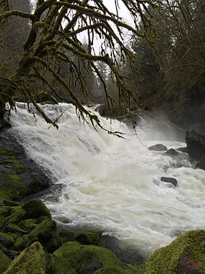
 Lake Creek Falls near Triangle Lake | |
| Etymology | For Triangle Lake[2] |
| Location | |
| Country | United States |
| State | Oregon |
| County | Lane |
| Physical characteristics | |
| Source | near Prairie Mountain |
| • location | Central Oregon Coast Range, Siuslaw National Forest |
| • coordinates | 44°16′43″N 123°34′18″W / 44.27861°N 123.57167°W[1] |
| • elevation | 2,752 ft (839 m)[3] |
| Mouth | Siuslaw River |
• location | Swisshome |
• coordinates | 44°03′19″N 123°47′47″W / 44.05528°N 123.79639°W[1] |
• elevation | 112 ft (34 m)[1] |
| Length | 40 mi (64 km)[4] |
| Basin size | 223 sq mi (580 km2)[4] |
| Discharge | |
| • average | 706 cu ft/s (20.0 m3/s)[4] |
Lake Creek is a major tributary of the Siuslaw River in Lane County in the U.S. state of Oregon. On average, the 40-mile (64 km) long creek contributes about a third of the lower Siuslaw's water volume.[4]
Beginning near Prairie Mountain near the Lane–Benton county border in the Central Oregon Coast Range, Lake Creek flows generally southeast through the Siuslaw National Forest to the vicinity of Horton, then southwest through the communities of Blachly, Triangle Lake, Greenleaf, and Deadwood. It enters the Siuslaw River at Swisshome, 29 miles (47 km) by water from the larger stream's mouth on the Pacific Ocean at Florence.[5]
- ^ a b c "Lake Creek". Geographic Names Information System (GNIS). United States Geological Survey. November 28, 1980. Retrieved February 6, 2016.
- ^ Giordano, Pete; Willamette Kayak and Canoe Club (2004). Soggy Sneakers: A Paddler's Guide to Oregon's Rivers (4th ed.). Seattle: The Mountaineers Books. pp. 64−65. ISBN 978-0-89886-815-9.
- ^ Source elevation derived from Google Earth search using GNIS source coordinates.
- ^ a b c d Palmer, Tim (2014). Field Guide to Oregon Rivers. Corvallis: Oregon State University Press. p. 100. ISBN 978-0-87071-627-0.
- ^ "United States Topographic Map". United States Geological Survey. Retrieved February 6, 2016 – via Acme Mapper. The map includes mile markers along Lake Creek and the Siuslaw River.
