| Lake Enriquillo | |
|---|---|
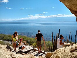
 View of Lake Enriquillo from Las Caritas. | |
 A satellite image of the lake (February 2023) | |
| Location | Hoya de Enriquillo |
| Coordinates | 18°30′N 71°35′W / 18.500°N 71.583°W |
| Lake type | saline lake |
| Primary inflows | Yaque del Sur |
| Primary outflows | evaporation |
| Basin countries | |
| Surface area | 375 km2 (145 sq mi)[1] |
| Max. depth | 52 m (171 ft) |
| Surface elevation | −46 m (−151 ft) |
| Islands | Isla Cabritos (Two former islands submerged by December 2011)[2] |
| Settlements | Boca de Cachón, La Descubierta, Postrer Río, Neyba, Duvergé, Jimaní |
| Official name | Lago Enriquillo |
| Designated | 15 May 2002 |
| Reference no. | 1179[3] |
Lake Enriquillo (Spanish: Lago Enriquillo) is a hypersaline lake in the Dominican Republic located in the southwestern region of the country. Its waters are shared between the provinces of Bahoruco and Independencia, the latter of which borders Haiti. Lake Enriquillo is the largest lake in both the Dominican Republic and Hispaniola, as well as the entire Caribbean. It is also the lowest point for an island country.[4]
- ^ Cite error: The named reference
LD-Octubre2011was invoked but never defined (see the help page). - ^ Cite error: The named reference
LD-Diciembre2011was invoked but never defined (see the help page). - ^ "Lago Enriquillo". Ramsar Sites Information Service. Retrieved 25 April 2018.
- ^ "Highest and Lowest Points of Countries of the World".
