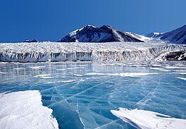
| Lake Fryxell | |
|---|---|
 Lake Fryxell | |
| Location | Taylor Valley, Victoria Land, Antarctica |
| Coordinates | 77°37′S 163°11′E / 77.617°S 163.183°E |
| Lake type | Endorheic |
| Primary inflows | Crescent Stream, Harnish Creek |
| Primary outflows | none |
| Catchment area | 230 km2 (89 sq mi) |
| Basin countries | (Antarctica) |
| Max. length | 5.8 km (3.6 mi) |
| Max. width | 2.1 km (1.3 mi) |
| Surface area | 7.8 km2 (3.0 sq mi) |
| Average depth | 3.2 m (10 ft) |
| Max. depth | 20 m (66 ft) |
| Water volume | 25.2×10⁶ m3 (890×106 cu ft) |
| Surface elevation | 18 m (59 ft) |
| Islands | moraine islands |
| Settlements | Lake Fryxell Camp, Lake Fryxell Hut |
Lake Fryxell is a frozen lake 4.5 kilometres (2.8 mi) long, between Canada Glacier and Commonwealth Glaciers at the lower end of Taylor Valley in Victoria Land, Antarctica. It was mapped in the early 1900s and named during Operation Deep Freeze in the 1950s. There are several forms of algae living in the waters[1] and a weather station located at the lake.[2]
- ^ Cite error: The named reference
COwas invoked but never defined (see the help page). - ^ "Lake Fryxell Meteorological Station". McMurdo Dry Valleys LTER. Retrieved 31 August 2021.
