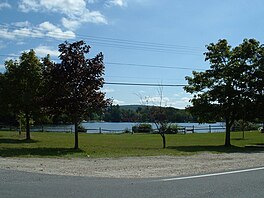
| Lake Garfield | |
|---|---|
 | |
| Location | Berkshire County, Massachusetts, U.S. |
| Coordinates | 42°10′59″N 73°11′53″W / 42.183°N 73.198°W |
| Type | Reservoir[1] |
| Basin countries | United States |
| Surface area | 275 acres (111 ha)[2] |
| Average depth | 16 ft (4.9 m)[2] |
| Max. depth | 35 ft (11 m)[2] |
| Surface elevation | 1,283 ft (391 m)[1] |
| Dam | Lake Garfield Dam[3] |
| Settlements | Monterey |
Lake Garfield is a 275-acre (111 ha) lake located about 0.5 miles (0.80 km) north of the center of Monterey, off Route 23 in Berkshire County, Massachusetts.
- ^ a b U.S. Geological Survey Geographic Names Information System: Lake Garfield
- ^ a b c Cite error: The named reference
MassGovrefwas invoked but never defined (see the help page). - ^ U.S. Geological Survey Geographic Names Information System: Lake Garfield Dam

