| Lake Huron | |
|---|---|
| |
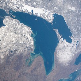
 Lake Huron, Georgian Bay, and the frozen North Channel (top) seen from the International Space Station on April 20, 2018 | |
 | |
| Location | North America |
| Group | Great Lakes |
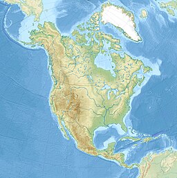
| Coordinates | 44°48′N 82°24′W / 44.8°N 82.4°W |
| Lake type | Glacial |
| Primary inflows | Straits of Mackinac, St. Marys River |
| Primary outflows | St. Clair River |
| Catchment area | 51,700 square miles (134,000 km2)[8] |
| Basin countries | Canada and the United States |
| Max. length | 206 mi (332 km)[8] |
| Max. width | 183 mi (295 km)[8] |
| Surface area | 23,007 square miles (59,590 km2)[8] |
| Average depth | 195 ft (59 m)[8] |
| Max. depth | 750 ft (229 m)[8] |
| Water volume | 844.8 cu mi (3,521 km3)[8] |
| Residence time | 22 years |
| Shore length1 | 1,850 mi (2,980 km) plus 1,980 mi (3,190 km) for islands[9] |
| Surface elevation | 577 ft (176 m)[8] |
| Islands | Manitoulin |
| Sections/sub-basins | Georgian Bay, North Channel |
| Settlements | Bay City, Alpena, Cheboygan, St. Ignace, Port Huron in Michigan; Goderich, Sarnia, Owen Sound in Ontario |
| References | [10] |
| 1 Shore length is not a well-defined measure. | |

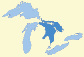
Lake Huron (/ˈhjʊərɒn, -ən/ HURE-on, -ən) is one of the five Great Lakes of North America. It is shared on the north and east by the Canadian province of Ontario and on the south and west by the U.S. state of Michigan. The name of the lake is derived from early French explorers who named it for the indigenous people they knew as Huron (Wyandot) inhabiting the region. Hydrologically, Lake Huron comprises the eastern portion of Lake Michigan–Huron, having the same surface elevation as Lake Michigan, to which it is connected by the 5-mile-wide (8.0 km), 20-fathom-deep (120 ft; 37 m) Straits of Mackinac. Combined, Lake Michigan–Huron is the largest freshwater lake by area in the world.[11][12][13] The Huronian glaciation was named from evidence collected from Lake Huron region. The northern parts of the lake include the North Channel and Georgian Bay. Saginaw Bay is located in the southwest corner of the lake. The main inlet is the St. Marys River from Lake Superior, and the main outlet is through the St. Clair River toward Lake Erie. Lake Huron has a fairly large drainage basin covering parts of Michigan and Ontario. Water flows through Lake Huron faster than the other Great Lakes with a retention time of only 22 years.
- ^ Cite error: The named reference
GLBathErwas invoked but never defined (see the help page). - ^ Cite error: The named reference
GLBathHurwas invoked but never defined (see the help page). - ^ Cite error: The named reference
GLBathMichwas invoked but never defined (see the help page). - ^ Cite error: The named reference
GLBathOntwas invoked but never defined (see the help page). - ^ Cite error: The named reference
GLBathSupwas invoked but never defined (see the help page). - ^ Cite error: The named reference
GLOBEwas invoked but never defined (see the help page). - ^ Cite error: The named reference
NOAA_GLERLwas invoked but never defined (see the help page). - ^ a b c d e f g h Cite error: The named reference
EPAphysicalwas invoked but never defined (see the help page). - ^ "Shorelines of the Great Lakes". Michigan Department of Environmental Quality. Archived from the original on April 5, 2015.
- ^ Wright, John W., ed. (2006). The New York Times Almanac (2007 ed.). New York: Penguin Books. p. 64. ISBN 0-14-303820-6 – via Archive.org.
- ^ Cite error: The named reference
DEQwas invoked but never defined (see the help page). - ^ "Great Lakes Sensitivity to Climatic Forcing: Hydrological Models". National Oceanic and Atmospheric Administration. 2006. Archived from the original on August 8, 2010.
Lakes Michigan and Huron are considered to be one lake hydraulically because of their connection through the deep Straits of Mackinac." Great Lakes Environmental Research Laboratory, part of the National Oceanic and Atmospheric Administration.
- ^ "Hydrological Components". Record Low Water Levels Expected on Lake Superior (PDF). United States Army Corps of Engineers. August 2007. p. 6. Archived from the original (PDF) on October 15, 2008.
Lakes Michigan and Huron are considered to be one lake, as they rise and fall together due to their union at the Straits of Mackinac
