| Lake James | |
|---|---|
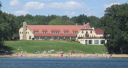
 Pokagon State Park's Potawatomi Inn on the First Basin of Lake James | |
| Location | Steuben County, Indiana |
| Coordinates | 41°42′00″N 85°02′20″W / 41.70000°N 85.03889°W |
| Type | mesotrophic glacial lake |
| Primary inflows | 3 creeks (largest is Croxton Ditch) plus minor tributaries |
| Primary outflows | Jimmerson Creek, located between Lake James and Jimmerson Lake |
| Catchment area | 4,322 acres (1,749 ha) |
| Basin countries | United States |
| Max. length | 2 mi (3.2 km) |
| Max. width | 1 mi (1.6 km) |
| Surface area | 1,228.56 acres (497.18 ha) |
| Average depth | 27 ft (8.2 m) |
| Max. depth | 88 ft (27 m) |
| Water volume | 33,171.22 acre⋅ft (40,916,100 m3) |
| Residence time | 312 days |
| Shore length1 | 17.5 mi (28.2 km) |
| Surface elevation | 965 ft (294 m) |
| Islands | Kemery Island |
| References | Lake Diagnostic Study[1] |
| 1 Shore length is not a well-defined measure. | |
Lake James is a natural lake located in the northeast corner of the state of Indiana in the United States. It is popular as a place for boating and fishing and has a wide variety of wildlife. As the state's fourth-largest natural lake, it has over 1,200 acres (490 ha) of surface water, and consists of three basins. Its water quality is ranked among the best in Indiana lakes. The lake is the largest of a group of lakes known as the James Lake Chain. These lakes are located mostly in Steuben County, Indiana, but also extend into southern Michigan.
During the 1700s the lake was part of a huge swamp that was the hunting grounds for the Potawatomi Indians. As European fur traders made wild game scarce, the Indians were persuaded to sell their land and move west. Pokagon State Park, located along all three of the lake's basins, is named in honor of two Potawatomi leaders: Simon Pokagon and his father Leopold. The park, with grounds of more than 1,200 acres (490 ha), is open all year. Camping sites are available, and the park features hiking trails, a toboggan, and two beaches. The park's Potawatomi Inn faces the north side of the lake's lower basin.
Lake James was named by surveyor James Watson Riley. It was first surveyed in 1831 by E. H. Lytle, and settlement began shortly thereafter. Settlement around the lake was initially slow, as there were no roads that provided access. The construction of a small railroad between the city of Angola and the lake's southern tip spurred development, as visitors could ride a train to Angola and connect to the lake. After arriving at the lake by train, many of the original cottage owners took a boat to their cottage. With the exception of Pokagon State Park and a private campground, nearly all of the lake's shoreline is now developed. Much of the development consists of cottages and homes, which began over 100 years ago. Two additional lakes of significant size, Jimmerson Lake and Snow Lake, are connected to Lake James. Water from these lakes flows west, and eventually reaches Lake Michigan.

