| Lake Kasumigaura 霞ヶ浦 | |
|---|---|
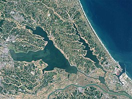
 The Landsat satellite picture of Lake Kasumigaura. | |
| Coordinates | 36°2′25″N 140°23′39″E / 36.04028°N 140.39417°E |
| Type | warm Monomictic |
| Primary inflows | Sakura and Naka rivers and more than 30 small rivers |
| Primary outflows | Tone River |
| Catchment area | 1,915 km2 (739 sq mi) |
| Basin countries | Japan |
| Surface area | 220 km2 (85 sq mi) |
| Average depth | 4 m (13 ft) |
| Max. depth | 7 m (23 ft) |
| Water volume | 0.848 km3 (687,000 acre⋅ft) |
| Shore length1 | 252 km (157 mi) |
| Surface elevation | 0.16 m (6.3 in) |
| Islands | 0 |
| Settlements | Tsuchiura, Ibaraki Kasumigaura, Ibaraki |
| 1 Shore length is not a well-defined measure. | |

Lake Kasumigaura (霞ヶ浦, Kasumigaura) is the second-largest lake in Japan, located 60 km to the north-east of Tokyo.

In a narrower sense and officially, Lake Kasumigaura refers to a waterbody with an area of 167.63 km2.[1][2] In a wider sense, Lake Kasumigaura can also refer to a group of contiguous lakes, which includes Lake Kasumigaura proper, hereby referred to as Nishiura (西浦), and two smaller lakes, Kitaura (北浦; 35.16 km2[1][2]) and Sotonasakaura (外浪逆浦; 5.85 km2[1][2]), and also encompasses the rivers connecting them. In this case the total area is 220 km2.
About 45% of the land surrounding the lake is natural landscape and 43.5% is agricultural land.
- ^ a b c 湖沼面積 (in Japanese). Geographical Survey Institute of Japan. 2008-10-01. Archived from the original on 2012-08-04. Retrieved 2013-09-15.
- ^ a b c 日本の主な湖沼 (in Japanese). Ministry of Land, Infrastructure, Transport and Tourism. 2002. Archived from the original on 2013-09-12. Retrieved 2013-09-15.
