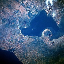
| Lake Managua | |
|---|---|
 1986 (north is to the left) | |
| Coordinates | 12°20′N 86°25′W / 12.333°N 86.417°W |
| Primary outflows | Tipitapa River |
| Basin countries | Nicaragua |
| Max. length | 65 km (40 mi) |
| Max. width | 25 km (16 mi) |
| Surface area | 1,024 km2 (395 sq mi) |
| Average depth | 9.5 m (31 ft) |
| Max. depth | 20 m (66 ft) |
| Surface elevation | 39 m (128 ft) |
| Islands | Momotombito |
| Settlements | Managua |
Lake Managua (Spanish: Lago de Managua, [maˈnaɣwa]), also known as Lake Xolotlán (Lago Xolotlán), is a freshwater lake in Nicaragua. At 1,042 km², it is approximately 65 kilometres (40 mi) long and 25 kilometres (16 mi) wide. Similarly to the name of Lake Nicaragua, its other name comes from the Nahuatl language, possibly from the Spanish Tlaxcaltec and Mexica allies but most likely from the Nicarao tribes that had already settled in the region.[1] The city of Managua, the capital of Nicaragua, lies on its southwestern shore.
