| Lake Memphremagog | |
|---|---|
| Lac Memphrémagog | |
 Lake Memphremagog | |
| Location | Memphrémagog Regional County Municipality, Quebec, Canada; Orleans County, Vermont, United States |
| Coordinates | 45°0′18″N 72°13′53″W / 45.00500°N 72.23139°W |
| Primary inflows | (clockwise from the mouth) Johns River (Vermont), Clyde River (Vermont), Barton River (Vermont), Black River (Vermont), Cherry River (Quebec) |
| Primary outflows | Magog River |
| Catchment area | 1,777 km2 (686 sq mi) |
| Basin countries | Canada / United States |
| Max. length | 51 km (32 mi) |
| Surface area | 110 km2 (42 sq mi) |
| Average depth | 15.5 m (51 ft) |
| Max. depth | 107 m (351 ft) |
| Surface elevation | 208 m (682 ft) |
| Islands | 21 |
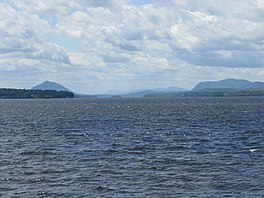
Lake Memphremagog (mem-frə-MAY-gog;[1] French: Lac Memphrémagog) is a fresh water glacial lake located between Newport, Vermont, United States and Magog, Quebec, Canada.[2] The lake spans both Quebec and Vermont, but is mostly in Quebec. Most of the watershed that feeds the lake is located in Vermont, and is a source for accumulated phosphorus, sediments, and other pollutants. Cleanup efforts since the late 1980s have improved the water quality. The lake furnishes potable water for 200,000 people.[citation needed]
- ^ "Lake Memphremagog — Vermont Historical Society". vermonthistory.org. Retrieved 17 February 2022.
- ^ Occhietti, Serge; Parent, Michel (1999). "Géographie physique et Quaternaire, 1999, vol. 53". Late Wisconsinan Deglaciation and Glacial Lake Development in the Appalachians of Southeastern Quebec. 53 (1): 117–135. Archived from the original on 2006-12-08. Retrieved 2006-12-24.


