| Lake Monongahela | |
|---|---|
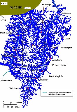
 Lake Monongahela during its most expansive period. Based on the map of John A. Harper; 1997. | |
| Location | Pennsylvania, Ohio & West Virginia |
| Coordinates | 39°58′N 80°00′W / 39.97°N 80°W |
| Lake type | former lake |
| Etymology | Monongahela River |
| Primary inflows | Laurentide Ice Sheet |
| Primary outflows | Ohio River |
| Basin countries | United States |
| First flooded | 900,000 years before present |
| Max. length | 122 mi (196 km) |
| Max. width | 365 mi (587 km) 212 mi (341 km) |
| Residence time | 170,000 years in existence |
| Surface elevation | c. 1,160 ft (354 m) |
| References | Lake Monongahela: Anatomy of an Immense Ice Age Pond; John A. Harper; Bureau of Topographic and Geologic Survey; 1997. |
Lake Monongahela was a proglacial lake in western Pennsylvania, West Virginia, and Ohio. It formed during the Pre-Illinoian ice epoch when the retreat of the ice sheet northwards blocked the drainage of these valleys to the north. The lake formed south of the ice front continued to rise until it was able to breach a low divide near New Martinsville, West Virginia. The overflow was the beginning of the process which created the modern Ohio River valley.
