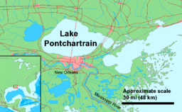
| Lake Pontchartrain | |
|---|---|
 Sentinel-2 image | |
 Map | |
| Location | Louisiana |
| Coordinates | 30°11′20″N 90°06′05″W / 30.18889°N 90.10139°W |
| Lake type | Estuary, saline |
| Basin countries | United States |
| Max. length | 40 mi (64 km) |
| Max. width | 24 mi (39 km) |
| Surface area | 630 sq mi (1630 km2) |
| Average depth | 12–14 ft (3.7–4.3 m) |
| Max. depth | 65 ft (20 m) |
| Surface elevation | 1 ft (0.30 m) |


Lake Pontchartrain (/ˈpɒntʃətreɪn/ PON-chə-trayn;[1] French: Lac Pontchartrain) is an estuary located in southeastern Louisiana in the United States. It covers an area of 630 square miles (1,600 km2) with an average depth of 12 to 14 feet (3.7 to 4.3 m). Some shipping channels are kept deeper through dredging. It is roughly oval in shape, about 40 miles (64 km) from west to east and 24 miles (39 km) from south to north.
In descending order of area, the lake is located in parts of six Louisiana parishes: St. Tammany, Orleans, Jefferson, St. John the Baptist, St. Charles, and Tangipahoa. The water boundaries were defined in 1979 (see list of parishes in Louisiana).
The lake is crossed by the Lake Pontchartrain Causeway, the longest continuous bridge over water in the world.[2] A power line also crosses the lake. Its towers stand on caissons in Lake Pontchartrain, and its length can be used to visually demonstrate the curvature of the Earth.[3]
- ^ "Oil from Gulf spill seeps into New Orleans' Lake Pontchartrain". The Associated Press. July 6, 2010.
Pontchartrain (pronounced PAHN-chuh-trayn)
[Respelled "ponch-a-train" in other sources] - ^ "Longest bridge over water (continuous)". Guinness World Records. Retrieved 2019-02-01.
- ^ "Power lines over Lake Pontchartrain elegantly demonstrate the curvature of Earth". ZME Science. 2017-07-27. Retrieved 2021-04-05.

