| Lake Springfield | |
|---|---|
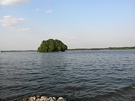
 Bay Island on Island Bay in Lake Springfield | |
| Location | Springfield, Illinois |
| Coordinates | 39°45′34″N 089°36′01″W / 39.75944°N 89.60028°W |
| Type | reservoir |
| Primary inflows | Lick Creek, Sugar Creek |
| Primary outflows | Sugar Creek |
| Catchment area | 265 sq mi (690 km2) |
| Basin countries | United States |
| Surface area | 3,965 acres (16.05 km2) |
| Max. depth | 27 feet (8.2 m) |
| Water volume | 17,500,000,000 US gal (0.066 km3) |
| Shore length1 | 57 mi (92 km) |
| Surface elevation | 560 ft (170 m) |
| Settlements | Springfield |
| 1 Shore length is not a well-defined measure. | |
Lake Springfield is a 3,965-acre (16.05 km2)[1] reservoir in the southeast of the capital city of Springfield, Illinois. It is 560 ft (170 m) above sea level. The lake was formed by building Spaulding Dam across Sugar Creek, a tributary of the Sangamon River. It is the largest municipally-owned body of water in Illinois.[1] The lake and the lands adjoining it are all owned by City Water, Light & Power, the municipal utility for the city of Springfield, which operates the Dallman Power Plant at the lake's north end. Multiple city parks border its more than 50 miles (80 km) of shoreline.
The lake is crossed by several bridges, including the Interstate 55 bridge. Its principal tributaries are Sugar Creek and Lick Creek, and its waters discharge through Spaulding Dam to the lower Sugar Creek valley, which flows into the Sangamon River.
The lake was created in the 1930s as a source of water for Springfield and to provide cooling water for the City Water, Light & Power coal-fired electrical generating plant. It has also served as a focus of local recreation. High-powered motor boats and aquatic sports are allowed on much of the lake, and the lake is known for warm-water fish.
- ^ a b "Lakes and Parks". City Water Light & Power. Retrieved 2023-05-22.

