| Lake Tight | |
|---|---|
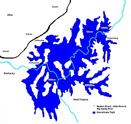
 Extent of Glacial Lake Tight about 500,000 YBP (years before present) | |
| Location | Ohio & West Virginia |
| Coordinates | 38°48′N 82°13′W / 38.8°N 82.21°W |
| Lake type | former lake |
| Etymology | William G. Tight |
| Primary inflows | Laurentide Ice Sheet |
| Primary outflows | Ohio River |
| Basin countries | United States |
| First flooded | 2,000,000 years before present |
| Max. length | c. 85 mi (137 km) |
| Max. width | c. 90 mi (140 km) – 212 mi (341 km) |
| Surface area | 9,920 sq mi (25,700 km2) |
| Average depth | 340 ft (100 m) |
| Max. depth | 400 ft (120 m) |
| Residence time | 170,000 years in existence |
| Surface elevation | c. 1,160 ft (354 m) |
| References | Goldthwaite, R. P., "The Teays Valley Problem, a Historical Perspective", pp. 3-8 in Wilton N. Melhorn, 1991, Geology and Hydrogeology of the Teays-Mahomet Bedrock Valley Systems, Geological Society of America Special Paper. |
Lake Tight, named for geologist William G. Tight, was a glacial lake in what is present-day Ohio, Kentucky, and West Virginia, during the Ice Age the early Pleistocene before 700,000 years.[1]
- ^ Goldthwaite, R. P., "The Teays Valley Problem, a Historical Perspective", pp. 3-8 in Wilton N. Melhorn, 1991, Geology and Hydrogeology of the Teays-Mahomet Bedrock Valley Systems, Geological Society of America Special Paper ISBN 978-0-8137-2258-0 Google books
