| Lake Winnipesaukee | |
|---|---|
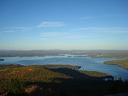
 Lake Winnipesaukee from the summit of Mt. Major | |
| Location | Belknap County and Carroll County, New Hampshire |
| Coordinates | 43°36′N 71°20′W / 43.600°N 71.333°W |
| Primary inflows | Gunstock River; Merrymeeting River; Melvin River; Red Hill River; Lake Waukewan canal |
| Primary outflows | Winnipesaukee River |
| Basin countries | United States |
| Max. length | 20.8 mi (33.5 km) |
| Max. width | 9.0 mi (14.5 km) |
| Surface area | 71 sq mi (180 km2) |
| Max. depth | 180 ft (55 m) |
| Shore length1 | 288 mi (463 km) |
| Surface elevation | 504 ft (154 m) |
| Islands | 258[1] |
| Settlements | see article |
| 1 Shore length is not a well-defined measure. | |
Lake Winnipesaukee (/ˌwɪnɪpəˈsɔːki/) is the largest lake in the U.S. state of New Hampshire, located in the Lakes Region at the foothills of the White Mountains. It is approximately 21 miles (34 km) long (northwest-southeast) and from 1 to 9 miles (1.6 to 14.5 km) wide (northeast-southwest), covering 69 square miles (179 km2)—71 square miles (184 km2) when Paugus Bay is included[2]—with a maximum depth of 180 feet (55 m).[3] The center area of the lake is called The Broads.[4]: 31
The lake contains at least 264 islands,[1] half of which are less than 0.25 acres (0.10 ha) in size, and is indented by several peninsulas, yielding a total shoreline of approximately 288 miles (463 km). The driving distance around the lake is 63 miles (101 km). It is 504 feet (154 m) above sea level. Winnipesaukee is the third-largest lake in New England after Lake Champlain and Moosehead Lake.
Outflow is regulated by the Lakeport Dam[5] in Lakeport, New Hampshire, on the Winnipesaukee River.
- ^ a b Bizer's list of islands of Lake Winnipesaukee
- ^ New Hampshire GRANIT database
- ^ "Lake Winnipesaukee bathymetry" (PDF). New Hampshire Fish and Game Department. State of New Hampshire.
- ^ Heald, Bruce D. (1 May 1998). Boats and Ports of Lake Winnipesaukee. Arcadia Publishing. ISBN 978-1-4396-2199-8.
- ^ "Lakeport Dam (LKPN3)". NH Dept. of Environmental Services. Retrieved May 20, 2016.

