Lake of Bays | |
|---|---|
| Township of Lake of Bays | |
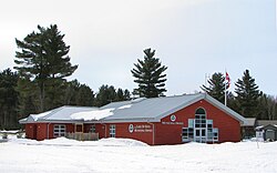
 Municipal office in Dwight | |
| Coordinates: 45°18′27″N 79°00′23″W / 45.30750°N 79.00639°W[1] | |
| Country | |
| Province | |
| Regional municipality | Muskoka |
| Incorporated | 1971 |
| Government | |
| • Type | Township |
| • Mayor | Terry Glover |
| • MP | Scott Aitchison |
| • MPP | Norm Miller (OPC) |
| Area | |
| • Land | 677.91 km2 (261.74 sq mi) |
| Population (2016)[3] | |
• Total | 3,167 |
| • Density | 4.7/km2 (12/sq mi) |
| Time zone | UTC-5 (EST) |
| • Summer (DST) | UTC-4 (EDT) |
| Postal code span | P0A, P0B, P1H |
| Area code(s) | 705, 249 |
| Website | www |
Lake of Bays is a township municipality within the District Municipality of Muskoka, Ontario, Canada.[1][4][5][6][7] The township, situated 193 kilometres (120 mi) north of Toronto, is named after the Lake of Bays. During the 2016 census, the township had a population of 3,167 and encompassed 677.91 square kilometres (261.74 sq mi) of land.[3]
Located in the northeast corner of Muskoka, Lake of Bays offers a natural landscape of forests, rocks, lakes and wetlands. It is an important destination for cottaging, recreation and tourism in Ontario. Currently, the economy of the township is primarily based on tourism, recreation, and the service sector with forestry and aggregate (composite) extraction contributing as well.
- ^ a b "Lake of Bays". Geographical Names Data Base. Natural Resources Canada. Retrieved 2014-07-01.
- ^ Cite error: The named reference
cp2011was invoked but never defined (see the help page). - ^ a b "Census Profile, 2016 Census: Lake of Bays, Township". Statistics Canada. Retrieved June 21, 2019.
- ^ "Ontario Geonames GIS (on-line map and search)". Ontario Ministry of Natural Resources and Forestry. 2014. Retrieved 2020-07-01.
- ^ "Toporama (on-line map and search)". Atlas of Canada. Natural Resources Canada. 12 September 2016. Retrieved 2020-07-01.
- ^ Restructured municipalities - Ontario map #5 (Map). Restructuring Maps of Ontario. Ontario Ministry of Municipal Affairs and Housing. 2006. Archived from the original on 2020-05-11. Retrieved 2020-07-01.
- ^ Map 5 (PDF) (Map). 1 : 700,000. Official road map of Ontario. Ministry of Transportation of Ontario. 2018-01-01. Retrieved 2020-07-01.
