| Lamar River | |
|---|---|
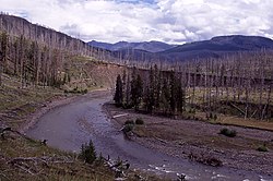
 The Lamar River in 1998 showing trees burned in the 1988 wildfires | |
 | |
| Location | |
| Country | United States |
| State | Wyoming |
| Physical characteristics | |
| Source | |
| • location | Absaroka Range, Wyoming |
| • coordinates | 44°21′19″N 109°49′33″W / 44.35528°N 109.82583°W[2] |
| Mouth | Yellowstone River |
• location | Tower Junction, Wyoming |
• coordinates | 44°55′45″N 110°24′07″W / 44.92917°N 110.40194°W[2] |
| Length | 40 mi (64 km) |
| Discharge | |
| • location | Tower Ranger Station |
| • average | 884 cu ft/s (25.0 m3/s)[1] |
| Basin features | |
| Tributaries | |
| • left | Soda Butte Creek |
| • right | Slough Creek |
The Lamar River is a tributary of the Yellowstone River, approximately 40 miles (64 km) long, in northwestern Wyoming in the United States. The river is located entirely within Yellowstone National Park.