This article needs additional citations for verification. (August 2018) |
Lambton | |
|---|---|
Neighbourhood | |
 A freight train crossing a railway bridge at the south end of Scarlett Road | |
 Vicinity of Lambton | |
| Coordinates: 43°39′27″N 79°29′33″W / 43.65750°N 79.49250°W | |
| Country | |
| Province | |
| City | Toronto |
| Settled | 1845 |
| Changed Municipality | 1998 Toronto from York |
| Government | |
| • MP | South of CPR: Arif Virani (Parkdale—High Park) North of CPR: Ahmed Hussen (York South-Weston) |
| • MPP | South of CPR: Bhutila Karpoche (Parkdale—High Park) North of CPR: Faisal Hassan (York South-Weston) |
| • Councillor | South of CPR: Gord Perks (Parkdale—High Park) North of CPR: Frances Nunziata (York South-Weston) |
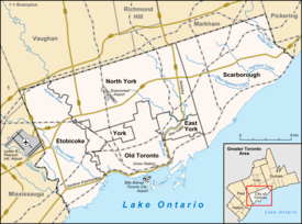
Lambton is a neighbourhood in the city of Toronto, Ontario, Canada. It is situated on the east bank of the Humber River north and south of Dundas Street West. It is bounded on the north by Black Creek, on the east by Jane Street and on the south by St. Mark's Road. The area west of Gooch Avenue and south of Dundas Street West is also known as "Warren Park", the name of the housing sub-division built in the 1950s. The portion south of Dundas Street West is within the 'Lambton Baby Point' neighbourhood as defined by the City of Toronto.
The neighbourhood is divided north/south by the Canadian Pacific Railway's Lambton Yard, which runs parallel to and north of Dundas Street West. Access between the northern and southern sections is available only via Jane Street and Scarlett Road, and via the Humber River Recreational Trail (foot/bicycle only).
