Lancaster, Kentucky | |
|---|---|
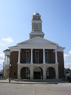
 Garrard County courthouse in Lancaster | |
 Location of Lancaster in Garrard County, Kentucky. | |
| Coordinates: 37°36′53″N 84°34′53″W / 37.61472°N 84.58139°W | |
| Country | United States |
| State | Kentucky |
| County | Garrard |
| Established | 1797 |
| Incorporated | 1837 |
| Named for | Lancaster, Pennsylvania |
| Government | |
| Area | |
• Total | 2.30 sq mi (5.96 km2) |
| • Land | 2.28 sq mi (5.91 km2) |
| • Water | 0.02 sq mi (0.05 km2) |
| Elevation | 1,007 ft (307 m) |
| Population (2020) | |
• Total | 3,901 |
• Estimate (2022)[3] | 4,010 |
| • Density | 1,710.09/sq mi (660.13/km2) |
| Time zone | UTC-5 (Eastern (EST)) |
| • Summer (DST) | UTC-4 (EDT) |
| ZIP codes | 40444, 40446 |
| Area code | 859 |
| FIPS code | 21-43840 |
| GNIS feature ID | 2404880[2] |
| Website | www |
Lancaster locally /ˈlæŋkəstər/[4] is a home rule-class city[5] in Garrard County, Kentucky, in the United States. It is the seat of its county.[6] As of the year 2020 U.S. census, the city population was 3,901.[7]
Located south of Lexington, Lancaster is the site of the Kennedy House, sometimes said to have been the setting for Uncle Tom's Cabin.[8] The Civil War training base Camp Dick Robinson was located nearby.
- ^ "2020 U.S. Gazetteer Files". United States Census Bureau. Retrieved March 18, 2022.
- ^ a b U.S. Geological Survey Geographic Names Information System: Lancaster, Kentucky
- ^ "Annual Estimates of the Resident Population for Incorporated Places in Kentucky: April 1, 2020 to July 1, 2022". United States Census Bureau. Retrieved May 26, 2023.
- ^ Cite error: The named reference
renwas invoked but never defined (see the help page). - ^ "Summary and Reference Guide to House Bill 331 City Classification Reform" (PDF). Kentucky League of Cities. Retrieved December 30, 2014.
- ^ "Find a County". National Association of Counties. Retrieved June 7, 2011.
- ^ "Incorporated Places: 2020 to 2022: Kentucky". U.S. Census Bureau. Retrieved October 18, 2023.
- ^ Kocher, Greg (November 30, 2008). "In Garrard, murky history as tourist lure". Lexington Herald-Leader. Retrieved January 6, 2016.