| Langar cum Barnstone | |
|---|---|
| Civil parish | |
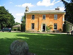
 Langar Hall | |
 Parish map | |
Location within Nottinghamshire | |
| Area | 6.28 sq mi (16.3 km2) |
| Population | 962 (2021) |
| • Density | 153/sq mi (59/km2) |
| OS grid reference | SK 73044 35078 |
| • London | 100 mi (160 km) SE |
| District | |
| Shire county | |
| Region | |
| Country | England |
| Sovereign state | United Kingdom |
| Places | Langar, Barnstone |
| Post town | NOTTINGHAM |
| Postcode district | NG13 |
| Dialling code | 01949 |
| Police | Nottinghamshire |
| Fire | Nottinghamshire |
| Ambulance | East Midlands |
| UK Parliament | |
| Website | langarbarnstone |
Langar cum Barnstone is a civil parish in the Rushcliffe borough, within the county of Nottinghamshire, England. The overall area had a population of 962 at the 2021 census,[1] a drop from 980 of the 2011 census.[2] The parish lies near the county border with Leicestershire. It lies 120 miles north of London, 4 miles south east of Bingham and 12 miles south east from the city of Nottingham.
- ^ UK Census (2021). "2021 Census Area Profile – Langar cum Barnstone (E04007987)". Nomis. Office for National Statistics. Retrieved 11 January 2024.
- ^ "Custom report - Nomis - Official Labour Market Statistics". www.nomisweb.co.uk. Retrieved 14 November 2020.
