Langenes Municipality
Langenes herred | |
|---|---|
 View of the village harbour of Stø | |
 Nordland within Norway | |
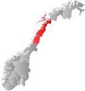
 Langenes within Nordland | |
| Coordinates: 69°01′07″N 15°09′21″E / 69.01861°N 15.15583°E | |
| Country | Norway |
| County | Nordland |
| District | Vesterålen |
| Established | 1 Jan 1919 |
| • Preceded by | Øksnes Municipality |
| Disestablished | 1 Jan 1964 |
| • Succeeded by | Øksnes Municipality |
| Administrative centre | Stø |
| Government | |
| • Mayor (1955-1963) | Otto Holm (Ap) |
| Area (upon dissolution) | |
| • Total | 103.4 km2 (39.9 sq mi) |
| • Rank | #513 in Norway |
| Highest elevation | 762.46 m (2,501.51 ft) |
| Population (1963) | |
| • Total | 2,040 |
| • Rank | #428 in Norway |
| • Density | 19.7/km2 (51/sq mi) |
| • Change (10 years) | |
| Demonyms | Langnesfjerding Langenesfjerding[2] |
| Official language | |
| • Norwegian form | Bokmål[3] |
| Time zone | UTC+01:00 (CET) |
| • Summer (DST) | UTC+02:00 (CEST) |
| ISO 3166 code | NO-1869[5] |
Langenes is a former municipality in Nordland county, Norway. The municipality, which existed from 1919 until 1964, encompassed the western shore of the Gavlfjorden in what is now Øksnes Municipality. It is located on the northern end of the large island of Langøya in the Vesterålen archipelago. The administrative centre was in the village of Stø, just east of the Langenes Church in the northern part of the municipality.[6]
- ^ "Høgaste fjelltopp i kvar kommune" (in Norwegian). Kartverket. 16 January 2024.
- ^ "Navn på steder og personer: Innbyggjarnamn" (in Norwegian). Språkrådet.
- ^ "Norsk Lovtidende. 2den Afdeling. 1932. Samling af Love, Resolutioner m.m". Norsk Lovtidend (in Norwegian). Oslo, Norway: Grøndahl og Søns Boktrykkeri: 453–471. 1932.
- ^ "Forskrift om målvedtak i kommunar og fylkeskommunar" (in Norwegian). Lovdata.no.
- ^ Bolstad, Erik; Thorsnæs, Geir, eds. (26 January 2023). "Kommunenummer". Store norske leksikon (in Norwegian). Kunnskapsforlaget.
- ^ Store norske leksikon. "Langenes" (in Norwegian). Retrieved 1 August 2012.