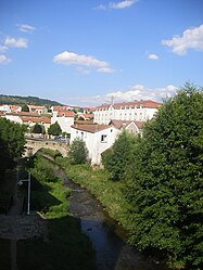
Langogne | |
|---|---|
 A view of the river (Langouyrou) flowing through Langogne | |
| Coordinates: 44°43′40″N 3°51′21″E / 44.7278°N 3.8558°E | |
| Country | France |
| Region | Occitania |
| Department | Lozère |
| Arrondissement | Mende |
| Canton | Langogne |
| Government | |
| • Mayor (2020–2026) | Marc Oziol[1] |
| Area 1 | 31.37 km2 (12.11 sq mi) |
| Population (2021)[2] | 2,867 |
| • Density | 91/km2 (240/sq mi) |
| Time zone | UTC+01:00 (CET) |
| • Summer (DST) | UTC+02:00 (CEST) |
| INSEE/Postal code | 48080 /48300 |
| Elevation | 886–1,097 m (2,907–3,599 ft) (avg. 913 m or 2,995 ft) |
| 1 French Land Register data, which excludes lakes, ponds, glaciers > 1 km2 (0.386 sq mi or 247 acres) and river estuaries. | |
Langogne (French pronunciation: [lɑ̃ɡɔɲ]; Occitan: Lengònha) is a commune in the Lozère department in southern France.
Located on the antique Regordane way, the Paris–Nimes railway line and the road RN 88 (Lyon–Toulouse), the city has long been a commercial crossroad between the Auvergne, the Cévennes and the Languedoc. It is one of the gateways of the historic county of Gévaudan and of the Occitanie region.
Langogne is situated in the valley of the Allier, in a mountainous area. It is crossed by the Langouyrou stream that joins the Allier in the north of the commune. The city is overlooked by hills: Margeride, Mount Milan (Beauregard), Bonjour Volcano.
- ^ "Répertoire national des élus: les maires" (in French). data.gouv.fr, Plateforme ouverte des données publiques françaises. 13 September 2022.
- ^ "Populations légales 2021" (in French). The National Institute of Statistics and Economic Studies. 28 December 2023.


