Langpih | |
|---|---|
Village | |
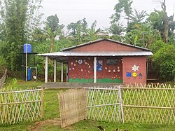
 Anganwadi center at Lampi | |
| Coordinates: 25°50′10.65″N 91°10′9.78″E / 25.8362917°N 91.1693833°E |
Langpih, also spelt Langpi, Lampi, or Lumpi is a village in northeast India.[1][2][3] It is located near the border of West Khasi Hills district, Meghalaya and Kamrup district, Assam.[4] In Meghalaya's administrative structure, it is under Kyrdum gram panchayat, Mawshynrut block, West Khasi Hills district, whereas Assam assigns it to No. 9 Dakhin Pub Boko gram panchayat, Boko-Bongaon block, Kamrup district, with the Postal Index Number 781129 (shared with Hahimbazar, Nalapara, and Samuka, which are all in No. 70 Dakhin Pub Luki gram panchayat).[5][6][7]
- ^ Lok Sabha debates (English Version), Lok Sabha Secretariat, 1988, p. 97
- ^ "Assam conducts function on disputed land", The Hindu, Chennai, India, 31 May 2008, retrieved 10 August 2010
- ^ Roy, Dipankar; Sarma, Pankaj (16 May 2010), "Lampi: a victim of one-upmanship; Progress eludes 'apple of discord'", The Telegraph, Calcutta, India, archived from the original on 19 May 2010, retrieved 18 August 2010
- ^ "Don't politicise Langpih: Meghalaya", Daily News and Analysis, 3 June 2008, retrieved 10 August 2010
- ^ "Kamrup", Name of Habitations in yearly status report, rural water supply programme, Department of Drinking Water and Sanitation, Government of India, 2010, retrieved 27 August 2010
- ^ "West Khasi Hills" (PDF), List of Habitations that have been provided with Water Supply during the year 2007–2008, Public Health Engineering Department, Government of Meghalaya, 2008, retrieved 27 August 2010
- ^ Pincode of Lower Lumpi, MapsOfIndia.com, retrieved 27 August 2010

