Native name: جزیره لارک | |
|---|---|
 | |
| Geography | |
| Location | Strait of Hormuz |
| Coordinates | 26°51′12″N 56°21′20″E / 26.85333°N 56.35556°E[1] |
| Adjacent to | Persian Gulf |
| Area | 49 km2 (19 sq mi) |
| Highest elevation | 81 m (266 ft) |
| Administration | |
| Province | Hormozgan |
| County | Qeshm County |
| Rural District | Larak Rural District |
| Largest settlement | Larak Shahri (pop. 466) |
| Jazīreh-ye Lārak North Lighthouse | |
| Constructed | 2008 |
| Construction | concrete tower |
| Height | 18 m (59 ft) |
| Shape | cylindrical tower with balcony and lantern[2][3] |
| Markings | unpainted tower |
| Power source | solar power |
| Focal height | 40 m (130 ft) |
| Range | 18 nmi (33 km; 21 mi) |
| Characteristic | Fl(2) W 10s |
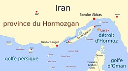
Larak Island (also Lark Island) is an island off the coast of Iran, which has been one of Iran's major oil export points since 1987. The narrowest part of the Strait of Hormuz at a distance of 24 miles (39 km) lies between this Iranian island and Oman's Quoin Island.[4]
- ^ "Larak Island Map, Weather and Photos". GetAMap. Retrieved 26 May 2013.
- ^ Rowlett, Russ. "Lighthouses of Iran". The Lighthouse Directory. University of North Carolina at Chapel Hill. Retrieved 1 October 2016.
- ^ NGA List of Lights – Pub.112 Retrieved 1 October 2016
- ^ Joyner, Christopher C. (1 January 1990). The Persian Gulf War: Lessons for Strategy, Law, and Diplomacy. Greenwood Publishing Group. p. 3. ISBN 978-0-313-26710-9.

