| Laramie River | |
|---|---|
 The Laramie River, as it flows past the site of old Fort Laramie | |
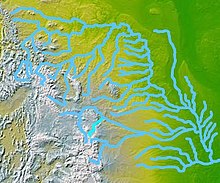
 Map highlighting the Laramie River (in bright blue, below and slightly left of center) | |
| Etymology | Named for Jacques La Ramie, French Canadian fur trapper[1] |
| Location | |
| Country | United States |
| State | Colorado, Wyoming |
| Cities | Laramie, Wheatland, Fort Laramie |
| Physical characteristics | |
| Source | Chambers Lake (Colorado) |
| • location | Larimer County, Colorado |
| • coordinates | 40°36′56″N 105°51′29″W / 40.61556°N 105.85806°W |
| • elevation | 9,192 ft (2,802 m)[2] |
| Mouth | North Platte River |
• location | Goshen County, Wyoming |
• coordinates | 42°11′59″N 104°31′47″W / 42.19972°N 104.52972°W[3] |
• elevation | 4,213 ft (1,284 m)[3] |
| Length | 280 mi (450 km) |
| Basin size | 4,564 sq mi (11,820 km2)[4] |
| Discharge | |
| • location | near Fort Laramie, 0.6 miles (1.0 km) from mouth[4] |
| • average | 129 cu ft/s (3.7 m3/s)[4] |
| • minimum | 0 cu ft/s (0 m3/s) |
| • maximum | 6,260 cu ft/s (177 m3/s) |
| Basin features | |
| Tributaries | |
| • left | North Laramie River |
| • right | Chugwater Creek |
The Laramie River is a tributary of the North Platte River, approximately 280 miles (450 km) long,[5] in the U.S. states of Colorado and Wyoming. The river was named for Jacques La Ramie, a fur trapper who visited the area in the early 19th century. Laramie County, Wyoming, the city of Laramie, and other geographical entities in the region have "Laramie" in their names.[1]
- ^ a b "Story Idea, Name Origins: Cheyenne & Laramie County". Visit Cheyenne. January 1, 2010. Archived from the original on August 28, 2013. Retrieved October 12, 2012.
- ^ Source elevation derived from Google Earth search using GNIS source coordinates.
- ^ a b "Laramie River". Geographic Names Information System. United States Geological Survey. October 13, 1978. Retrieved October 12, 2012.
- ^ a b c "Water-Data Report 2011: 06670500 Laramie River near Fort Laramie, WY" (PDF). United States Geological Survey. Retrieved October 12, 2012.
- ^ U.S. Geological Survey. National Hydrography Dataset high-resolution flowline data. The National Map Archived 2012-03-29 at the Wayback Machine, accessed March 21, 2011