| Last Mountain Creek | |
|---|---|
 Confluence of Last Mountain Creek, Qu'Appelle River, and Wascana Creek | |
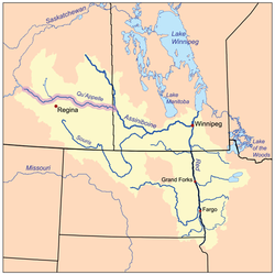
 The Red River drainage basin, with the Qu'Appelle River highlighted | |
| Location | |
| Country | |
| Province | |
| Physical characteristics | |
| Source | Last Mountain Lake |
| • coordinates | 50°44′36″N 104°52′04″W / 50.7432°N 104.8677°W |
| • elevation | 490 m (1,610 ft) |
| Mouth | Qu'Appelle River |
• location | Craven |
• coordinates | 50°42′24″N 104°49′32″W / 50.70667°N 104.82556°W |
| Length | 6 km (3.7 mi) |
| Basin features | |
| River system | Red River |
| [1][2][3] | |
Last Mountain Creek is a river in south-central Saskatchewan. It is a tributary of the Qu'Appelle River[1] in a region called the Prairie Pothole Region of North America, which extends throughout three Canadian provinces and five U.S. states. It is also within Palliser's Triangle and the Great Plains ecoregion.[4]
The river is part of the Upper Qu'Appelle River watershed and starts at the southern end of Last Mountain Lake. It travels in a southerly direction for about 6 kilometres (3.7 mi) until it meets the Qu'Appelle River in the Qu'Appelle Valley, which was formed during the last ice age. During years in which the Qu'Appelle River is high, Last Mountain Creek naturally reverses direction and flows into Last Mountain Lake.[5] Craven Dam is located east of Last Mountain Creek's mouth on the Qu'Appelle River on the eastern side of the village of Craven. The gates of the dam are used to regulate water flows along the Qu'Appelle and can be closed to backflood water up Last Mountain Creek and into Last Mountain Lake.[6]
- ^ a b Government of Canada, Natural Resources Canada. "Place names - Last Mountain Creek". www4.rncan.gc.ca.
- ^ The Encyclopedia of Saskatchewan. "Qu'Appelle River". Archived from the original on 3 May 2012. Retrieved 2 August 2008.
- ^ "Canada Drainage Basins". The National Atlas of Canada, 5th edition. Natural Resources Canada. 1985. Retrieved 24 November 2010.
- ^ "Drought in Palliser's Triangle | The Canadian Encyclopedia". www.thecanadianencyclopedia.ca.
- ^ "WSA working to raise low water levels in Last Mountain Lake ahead of summer | Globalnews.ca". Global News.
- ^ Foster, Scott. "Water diverted to Last Mountain". Reginacity. Regina Leader Post. Retrieved 11 December 2021.

