Lat Phrao
ลาดพร้าว | |
|---|---|
 Sunflower field, the only one in Bangkok, behind Satriwitthaya 2 School | |
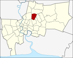
 Khet location in Bangkok | |
| Coordinates: 13°48′13″N 100°36′27″E / 13.80361°N 100.60750°E | |
| Country | Thailand |
| Province | Bangkok |
| Seat | Lat Phrao |
| Khwaeng | 2 |
| Khet established | 4 September 1989 |
| Area | |
| • Total | 22.157 km2 (8.555 sq mi) |
| Population (2017) | |
| • Total | 120,394[1] |
| • Density | 5,599.72/km2 (14,503.2/sq mi) |
| Time zone | UTC+7 (ICT) |
| Postal code | 10310 and 10230 |
| Geocode | 1038 |
Lat Phrao (Thai: ลาดพร้าว, RTGS: Lat Phrao, pronounced [lâːt pʰráːw]) is one of the 50 districts (khet) of Bangkok, Thailand. The district is bound by six other districts (from north clockwise): Bang Khen, Bueng Kum, Bang Kapi, Wang Thonglang, and Chatuchak.
- ^ "Population and House Report for Year 2017 (see page 2 for data of this district)". Department of Provincial Administration, Ministry of Internal Affairs. Retrieved 2018-04-01. (Search page)